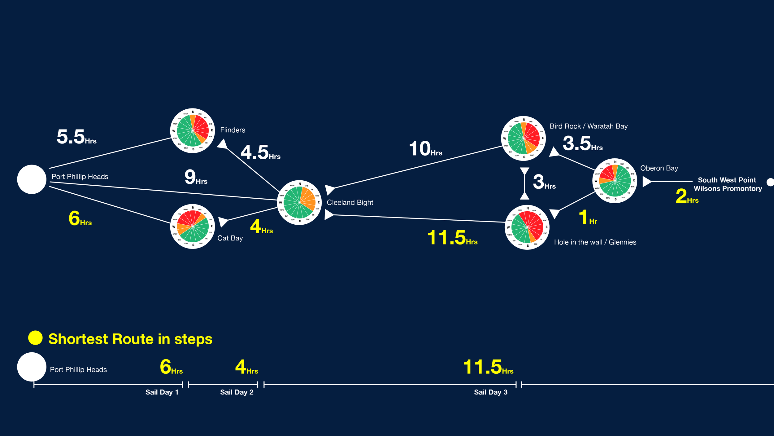
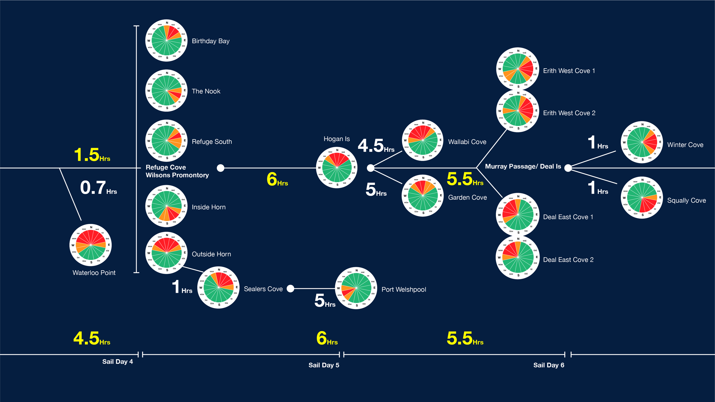
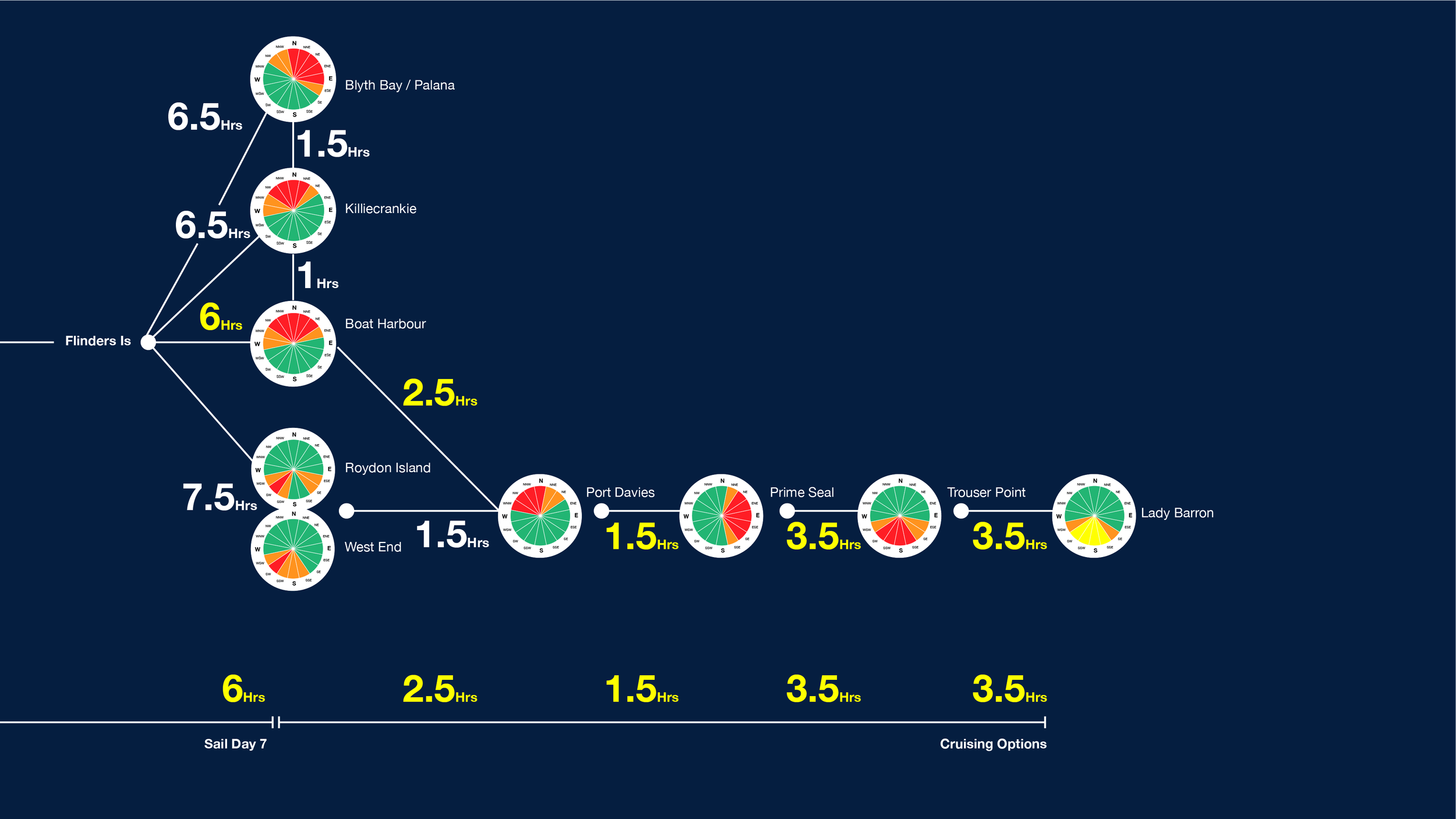
Port Phillip Heads
to Flinders Island (Lady Barron).

This is a passage plan for a January trip to Flinders Island from Port Phillip Bay. This is the culmination of what will be nearly 4 months worth of exploring the area over the last 8 Years. Sailing Bass Strait is not everyones cup of tea. It has been said that it’s not cruising grounds at all because it is too spicy. Thats likely because they are on a tight schedule and have places to be, and found conditions too spicy. I’ve found that having time is your secret weapon in the strait as you will see in the next section. Being able to wait for perfect weather windows is how to do this safely. So to start with we look at January climate data, and start our plan there. You have to start somewhere, and you have to have a plan or you have no plan. I like evidence, as a way to inform decisions. And weather / wind data and research is a good start.

Side note: I met a bloke at the Cruising Club in Queenscliff and he was leading a similar trip to this with eight or more boats, I was impressed and keen to riff on weather trends and modelling, routes and anchorages. With a little coaxing I realised that this ‘ol-mate’ firmly believed that the weather in the strait was consistent year in year out. Like on the 7th it blows from the west, moderate… but by the 12th you’ll be faced with easterlies. It was total horse shit. This is not how weather works anywhere, least of all the strait. I’m offering this up for some mates, and anyone else who wants to lean in. I’m not an expert. this is provided in good faith. Misdirected sailing can be miserable at best and the worst makes headlines. Ol mate sailed back in through the heads a few days later, shocked and a little rattled! It was not the weather he’d been planning!

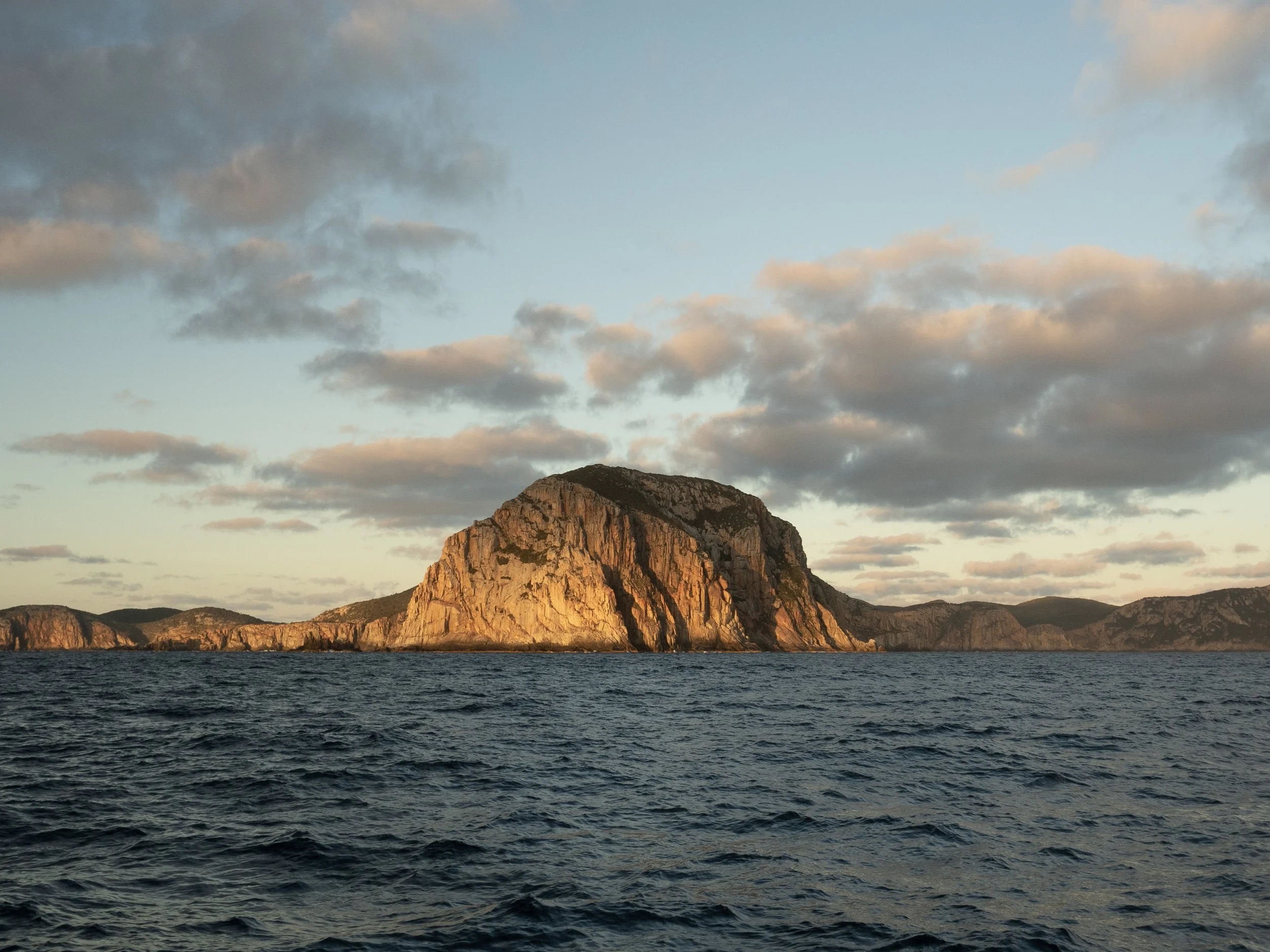
Erith Island from the Eastern approach to Murray Passage.


Section One: Planning then plan

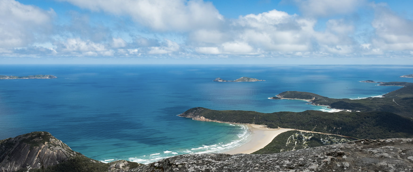
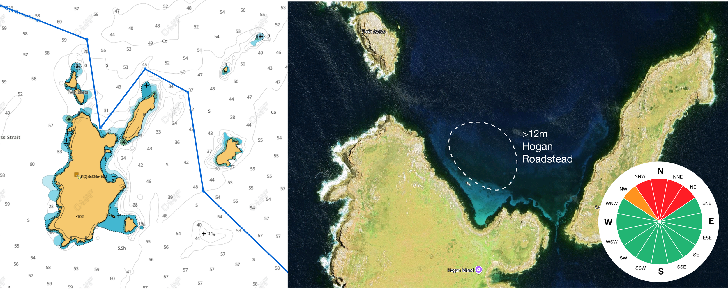
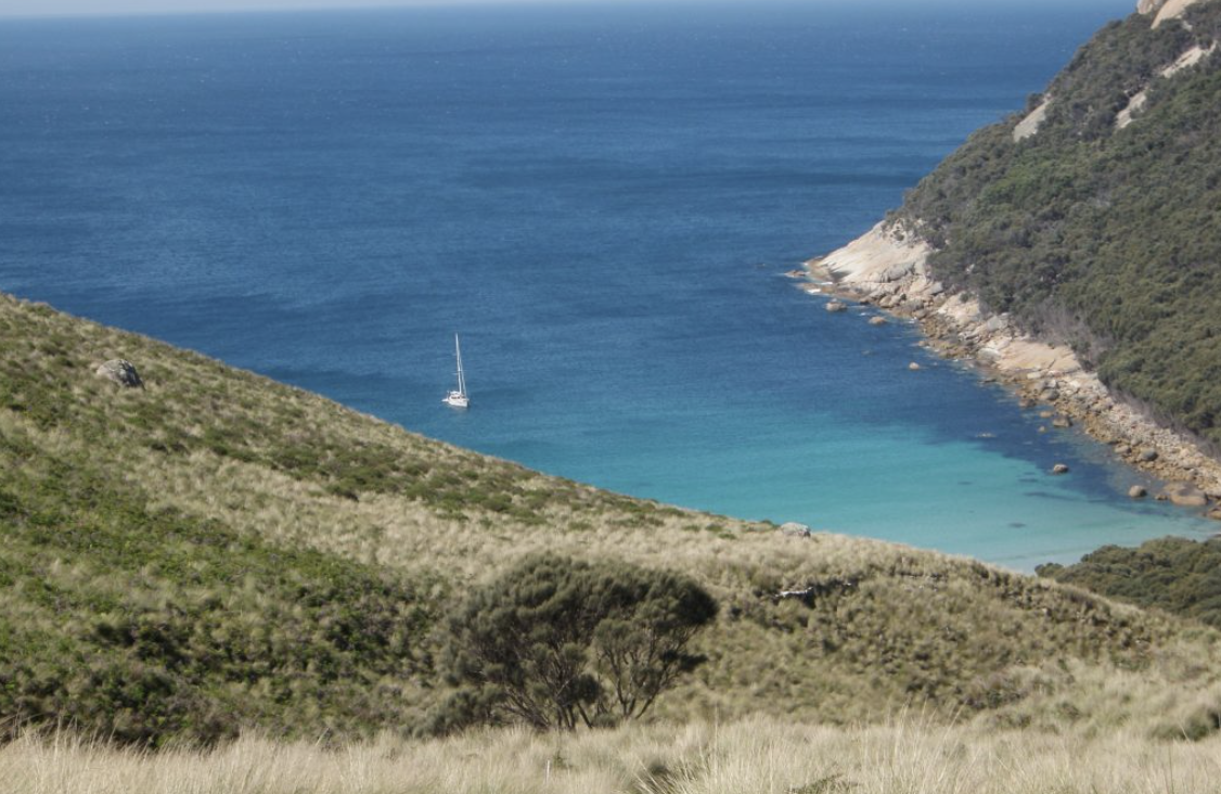
Hogan island. A place that shouts ‘UNIHABITED’ and with good reason.

Hogan island is our data datum. It’s a good one because it’s a bad one. I like making conservative choices when children and families are involved in adventures, so using the location that is both central to our intended course and perhaps the most windswept and hostile of the lot feels ‘Good-Bad’. And importantly it has a BOM Automatic Weather Station on it (AWS).

Check out the realtime situation at HOGAN HERE

Wind roses display the seasonal / monthly or annual wind trends in both direction / velocity and duration. Each hour is averaged, given a velocity and direction then plotted. With the wind rose you can get to a point where you can forecast the safe sailing window likelihood and duration. The fun sailing zone is winds up to 15 knots, in daylight hours. Anything more than this is burley and becomes hard work and arduous for the durations we are planning. Sure it will be quicker, but the cold hard reality is that it exposes you and your crew to motion sickness, which leads to accidents, which can compound and IMHO just not worth it.

If you like your crew, and want to keep them around… This is Cruising! treat them nice!

Add the spicy sauce of the fact the BOM states forecast wind gust can be 40% stronger than forecast. Your 15kn passage turns into 24knot white water rollercoaster. Been there, done that… it happens.

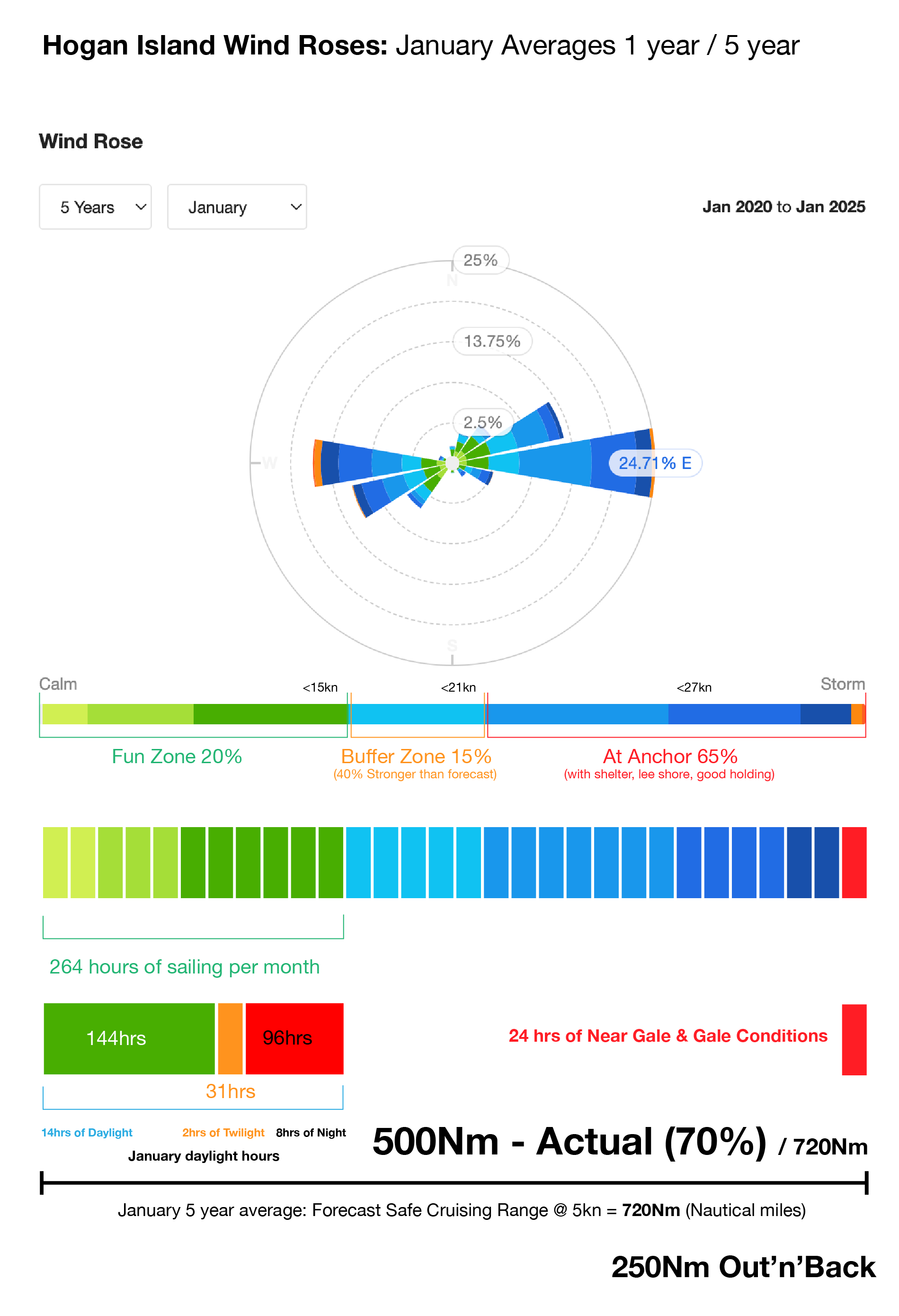
So If you can follow the above, Ignore the rose itself for now and focus on the summary bar, we end up with 11 days of favourable conditions, then minus off the hours that are dark, and dont use the twilight as a buffer if needed, you end up at 144hrs total (or 20% of the month). That creates the opportunity to sail 720Nm. That is based on a 5 knot boat speed. You might go faster? It’s true, the wind trends are favourable to fast sailing angles for the course we want to sail. But lets leave that to providence and enjoy making a 7hr passage in 5hr and not add it to our planning. Again, stuff happens.

If we are lucky we get to sail our course. If we dont, overall it could make is travel 30% further. So if 720Nm is the distance we can own, we will spend that sailing only 500nm. And that has us sailing everyday when the conditions permit… again, be nice to your crew. Plus, you have to get back.

So in summary we land on a 225 - 250Nm outward cruising range, or 48hrs of favourable sail time if the forecast works and we actually want to travel that far, remembering we have to sail it back.
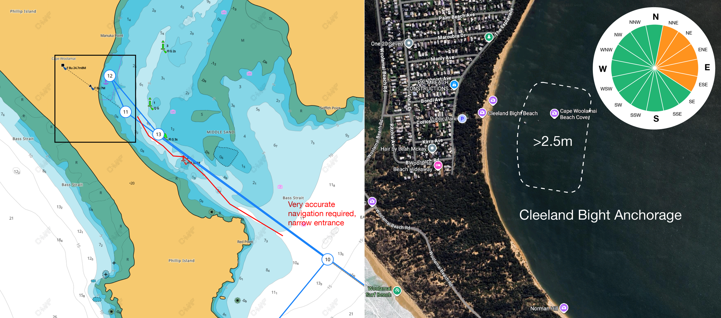
Click to zoom.


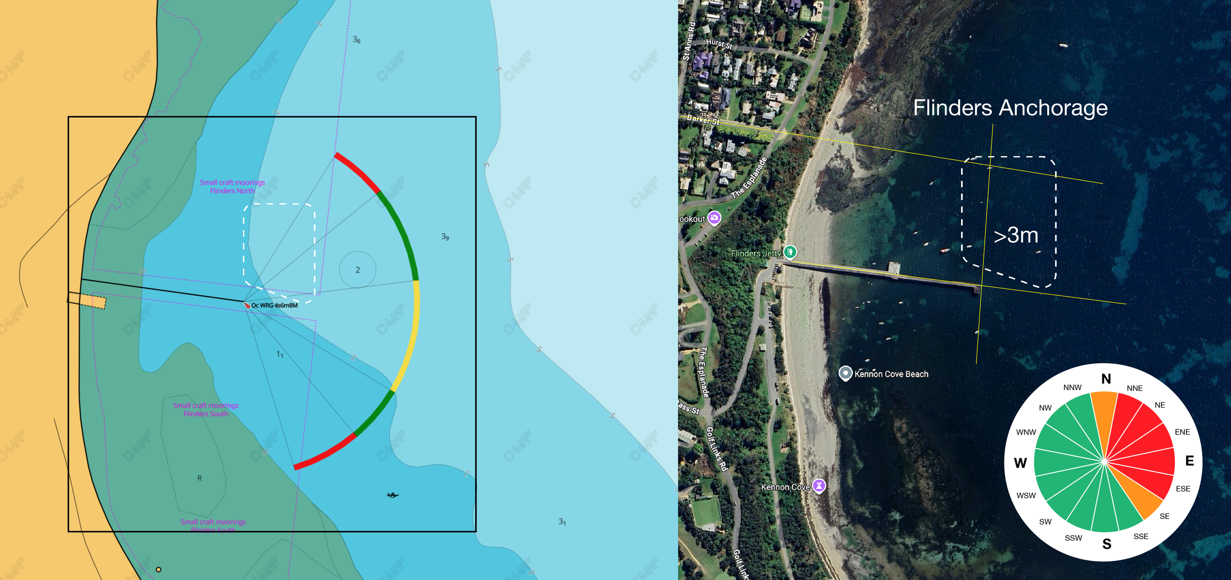
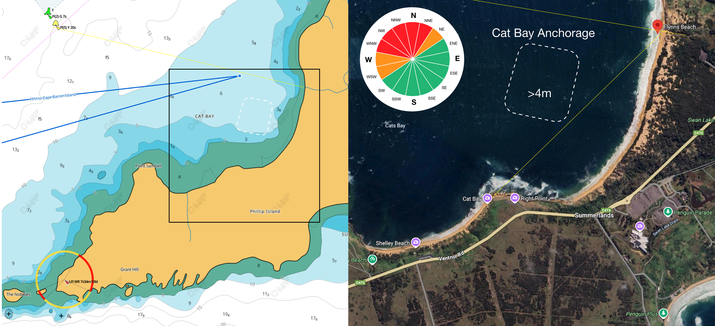
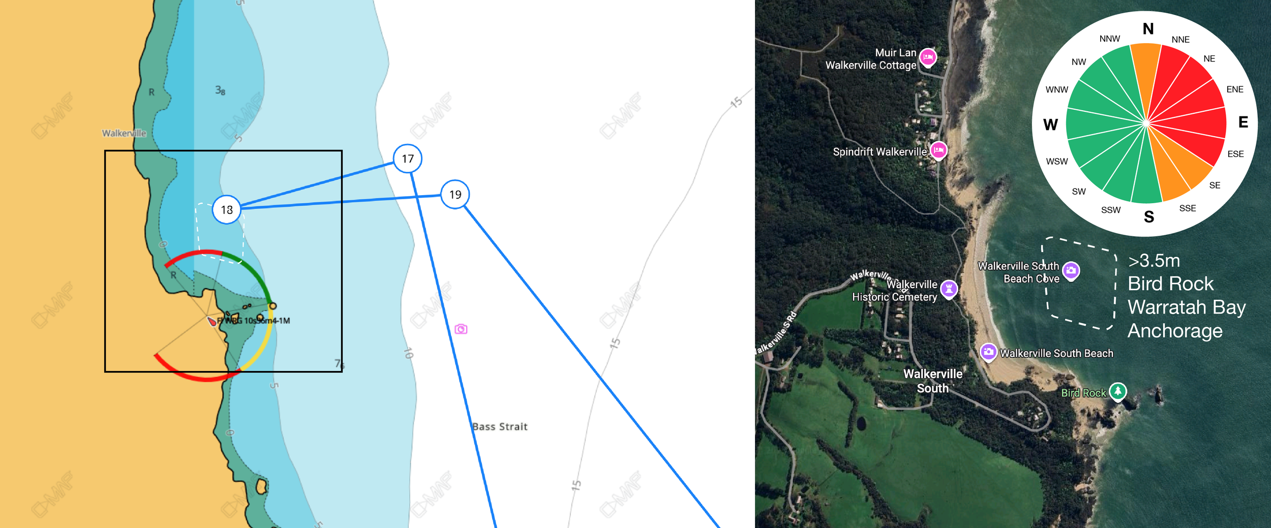
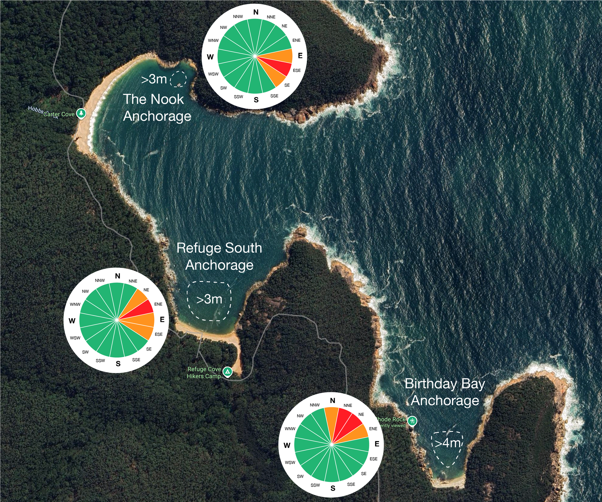
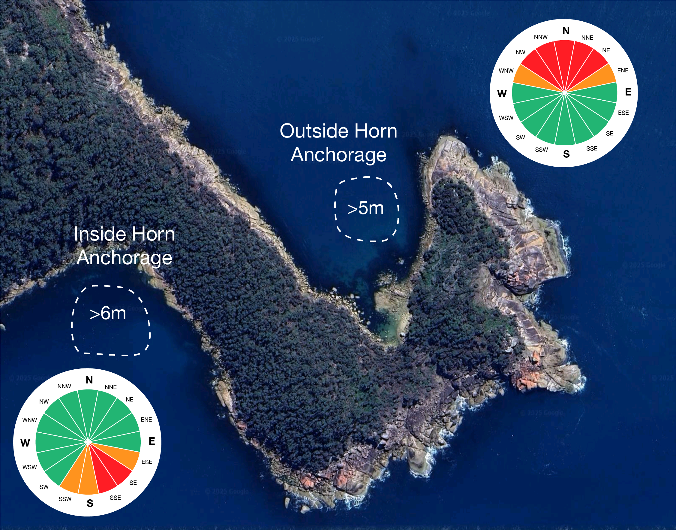
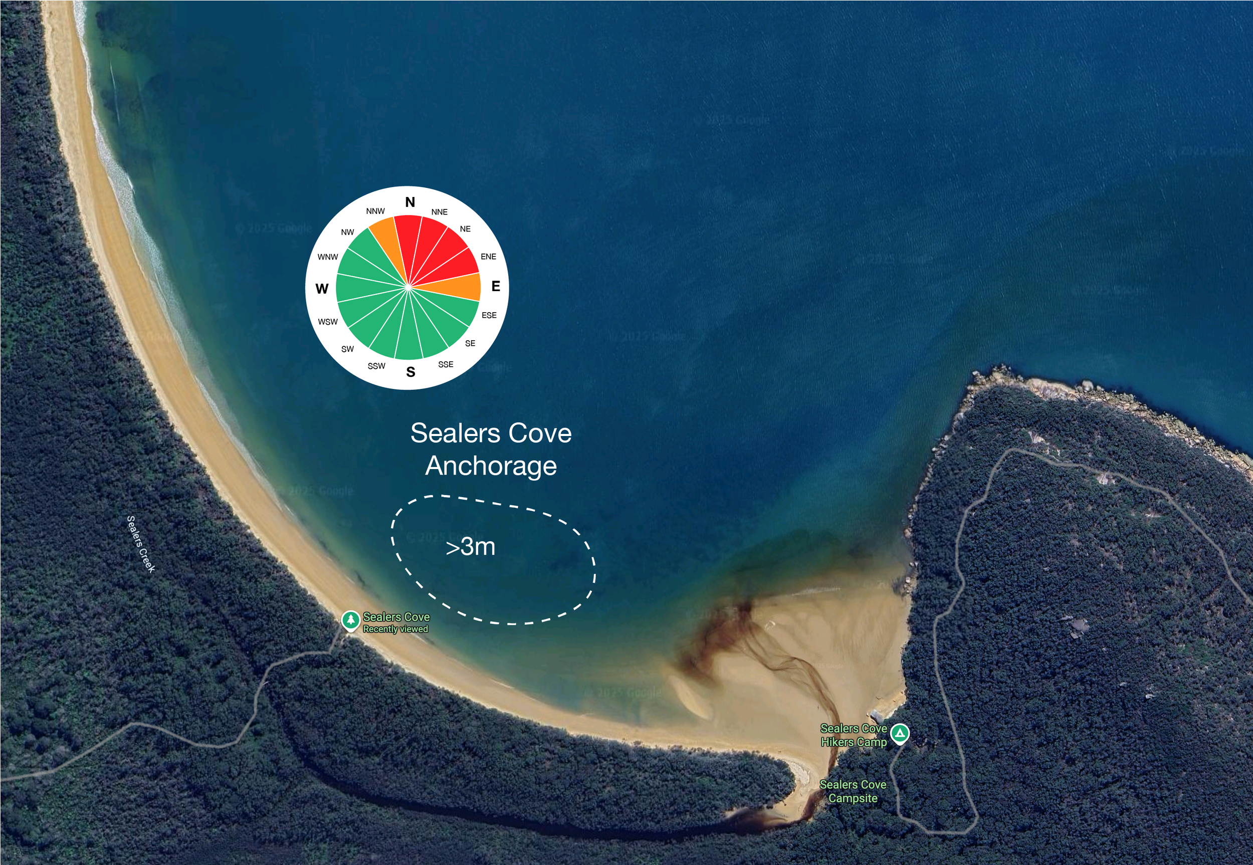
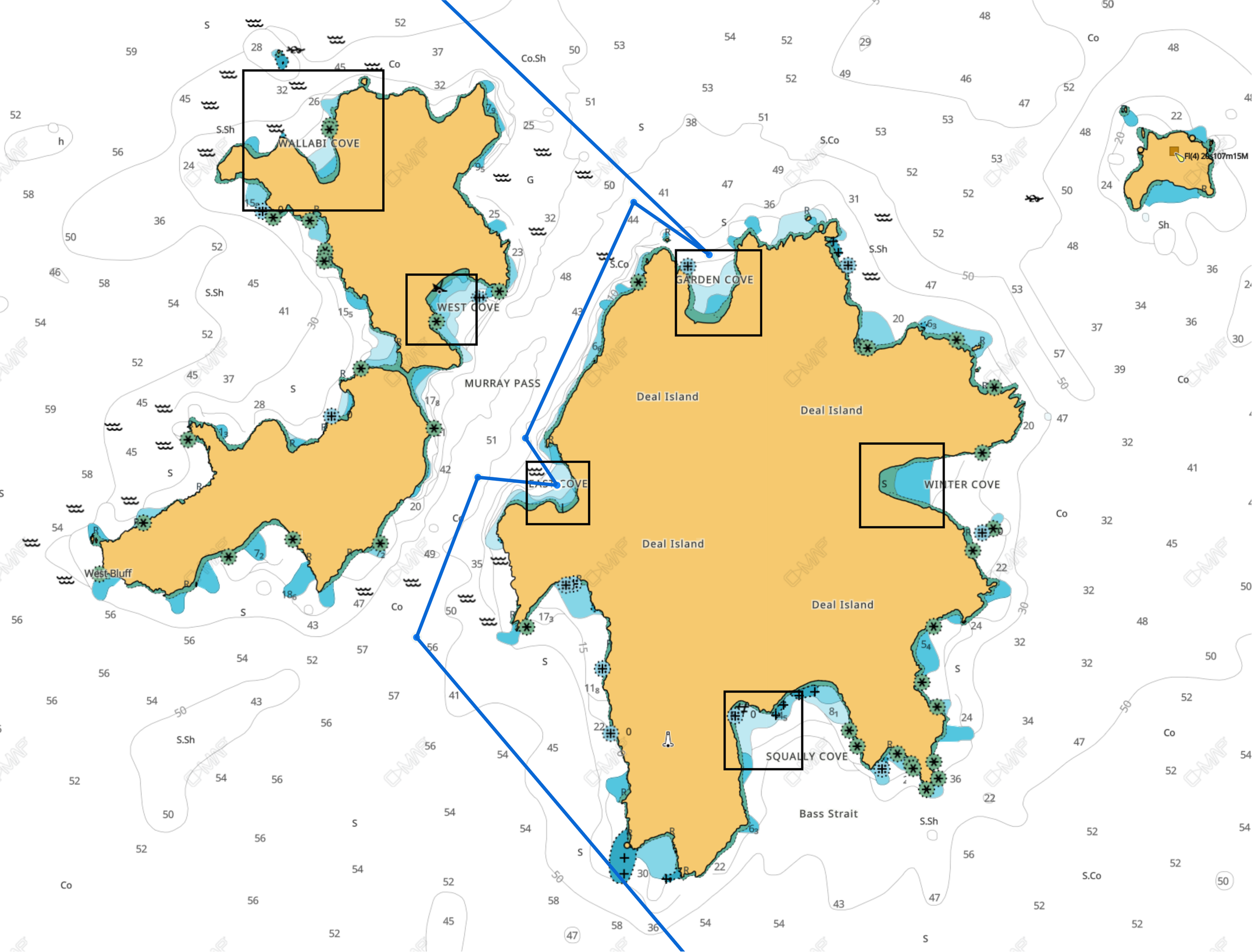
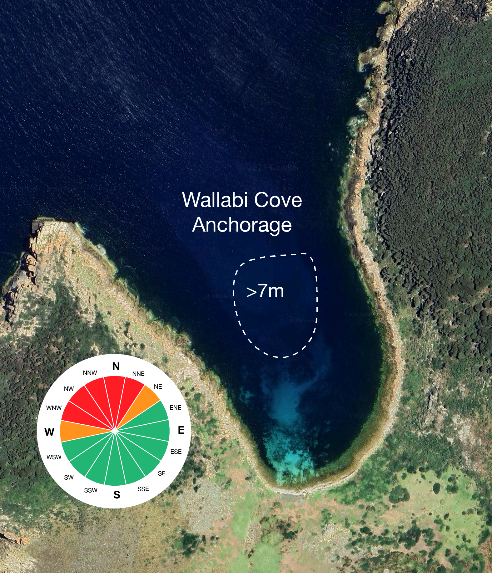
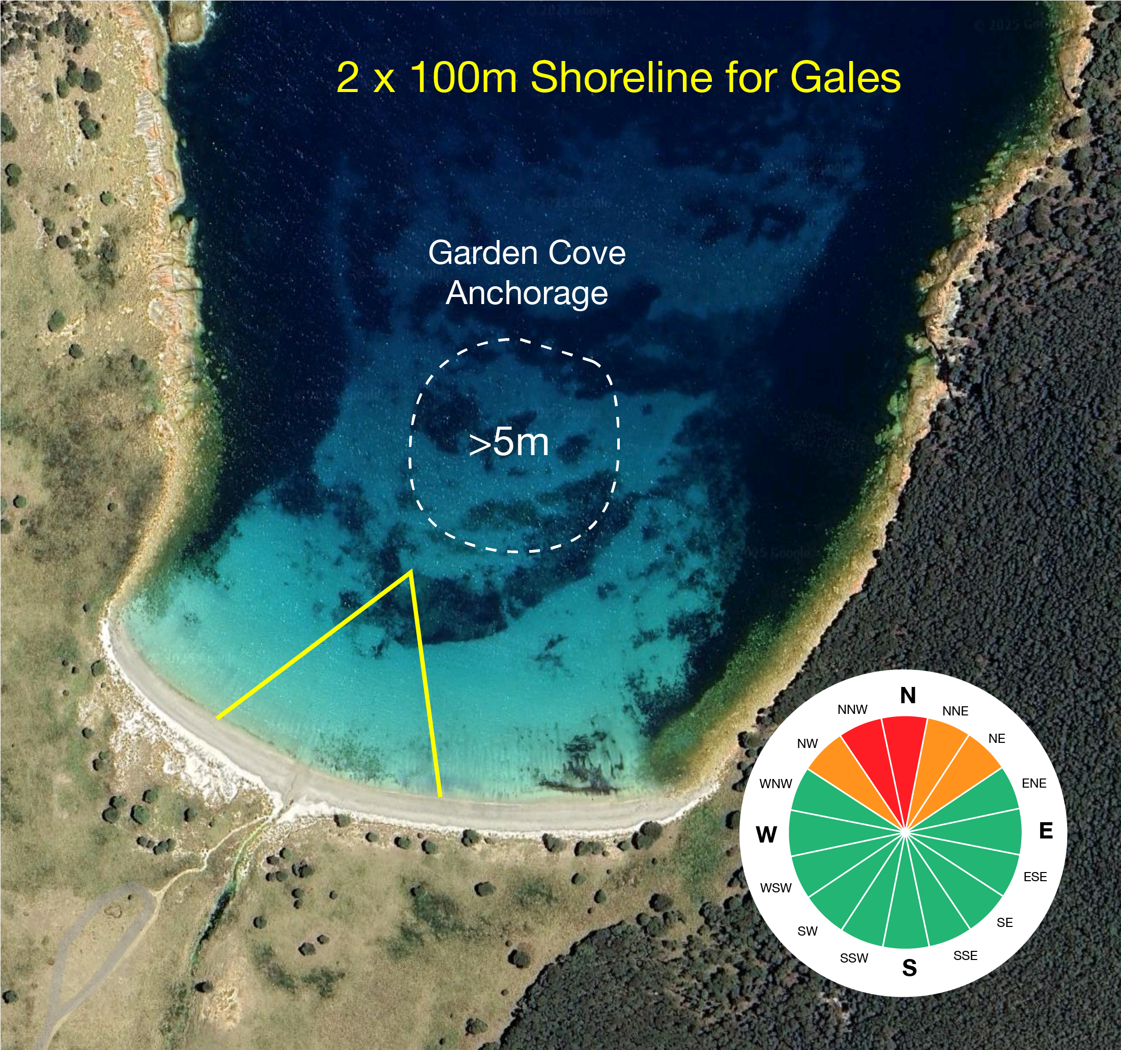
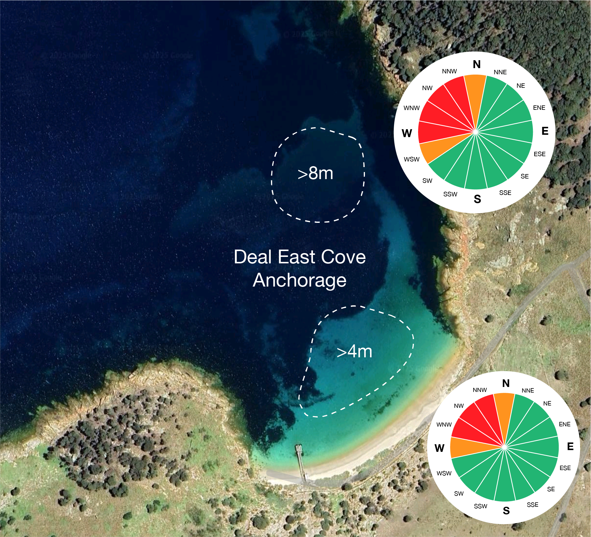
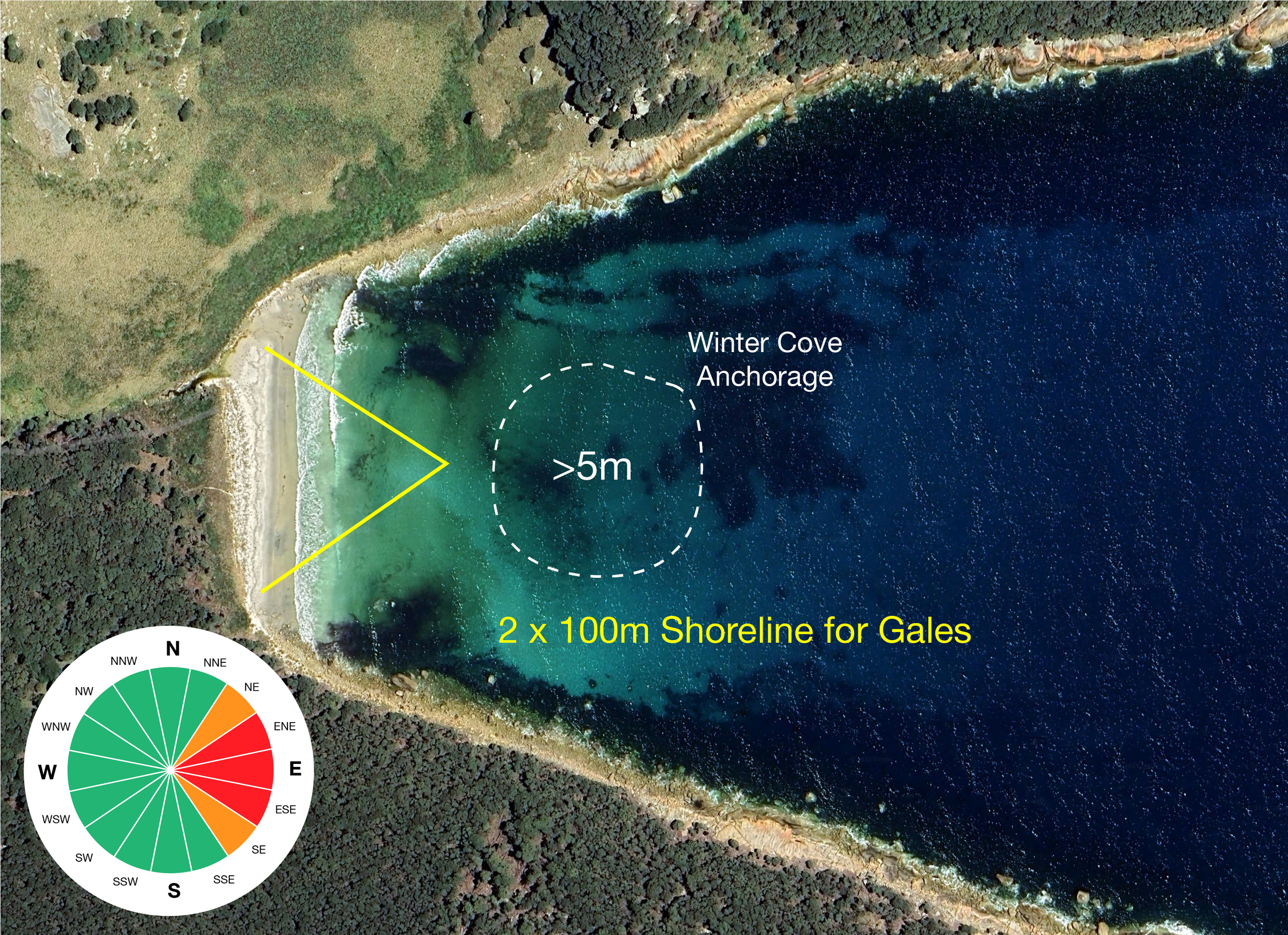
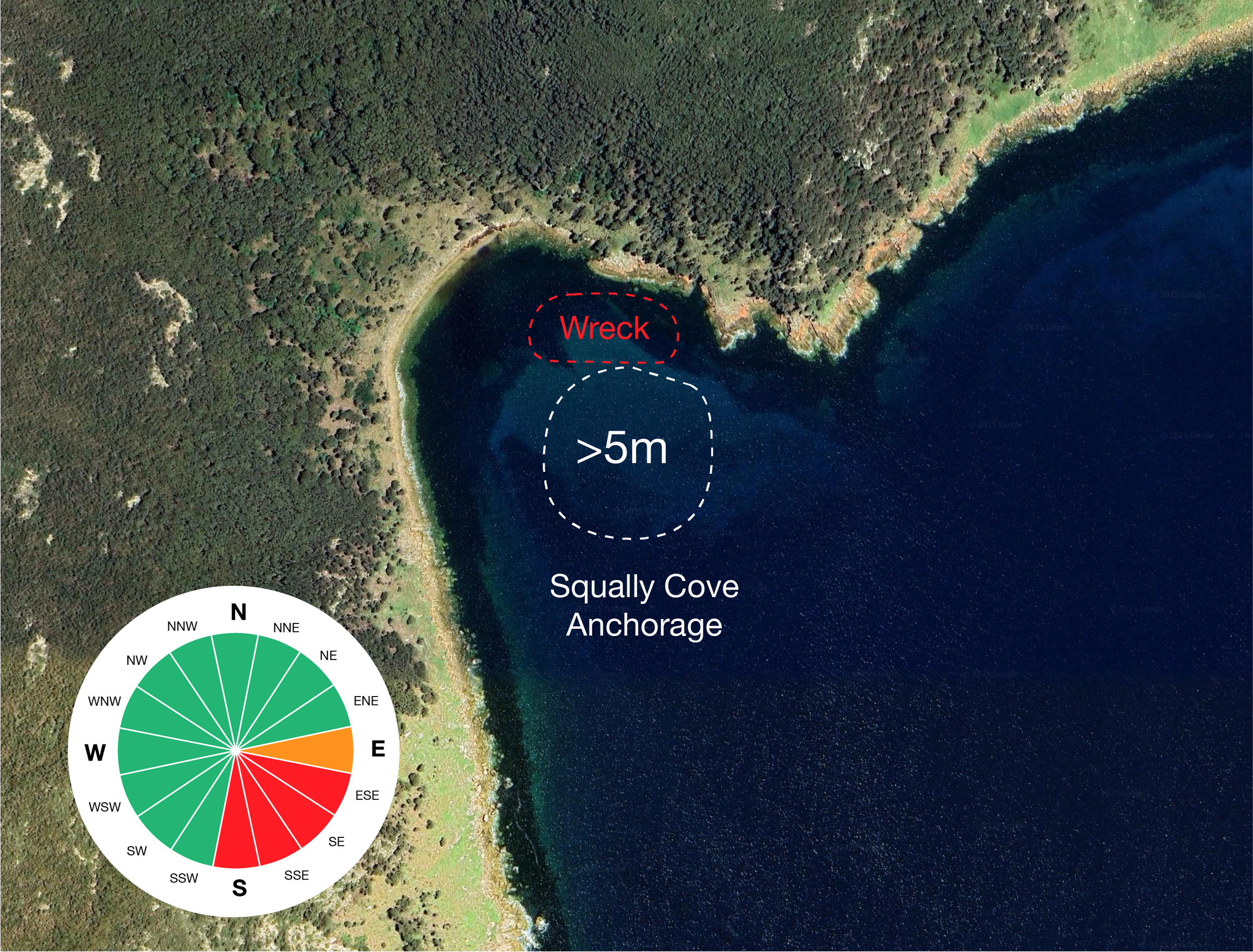
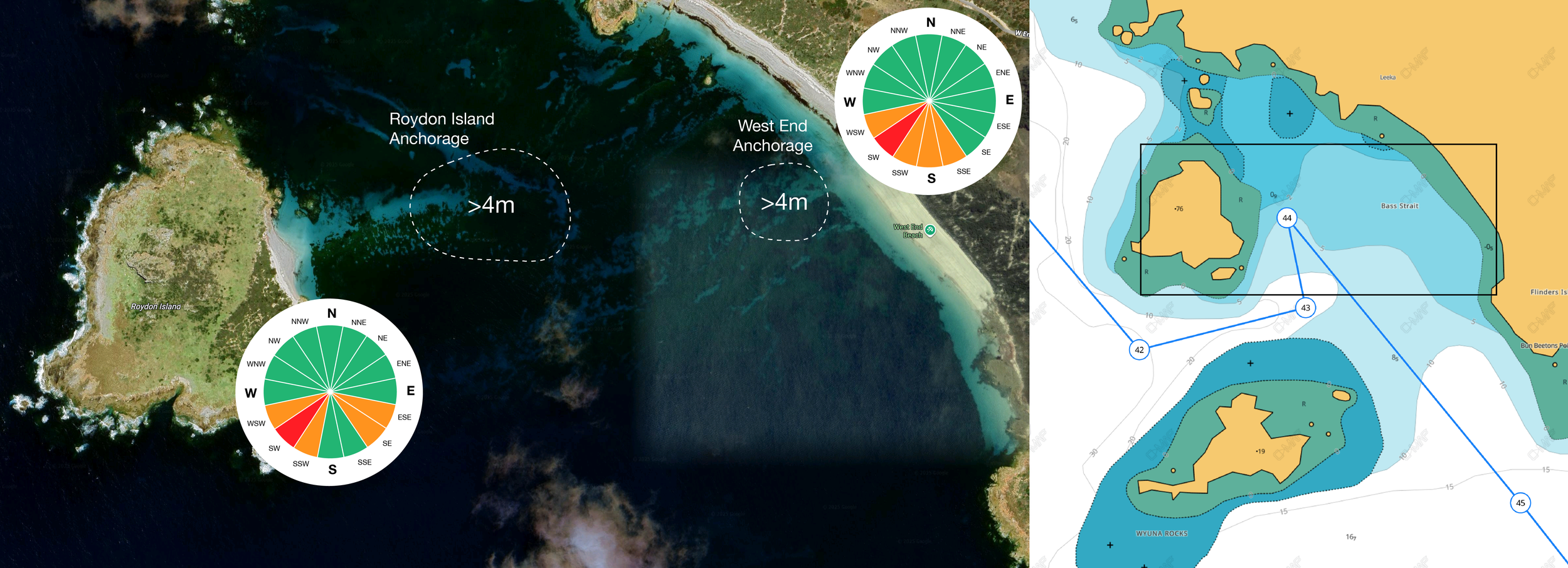
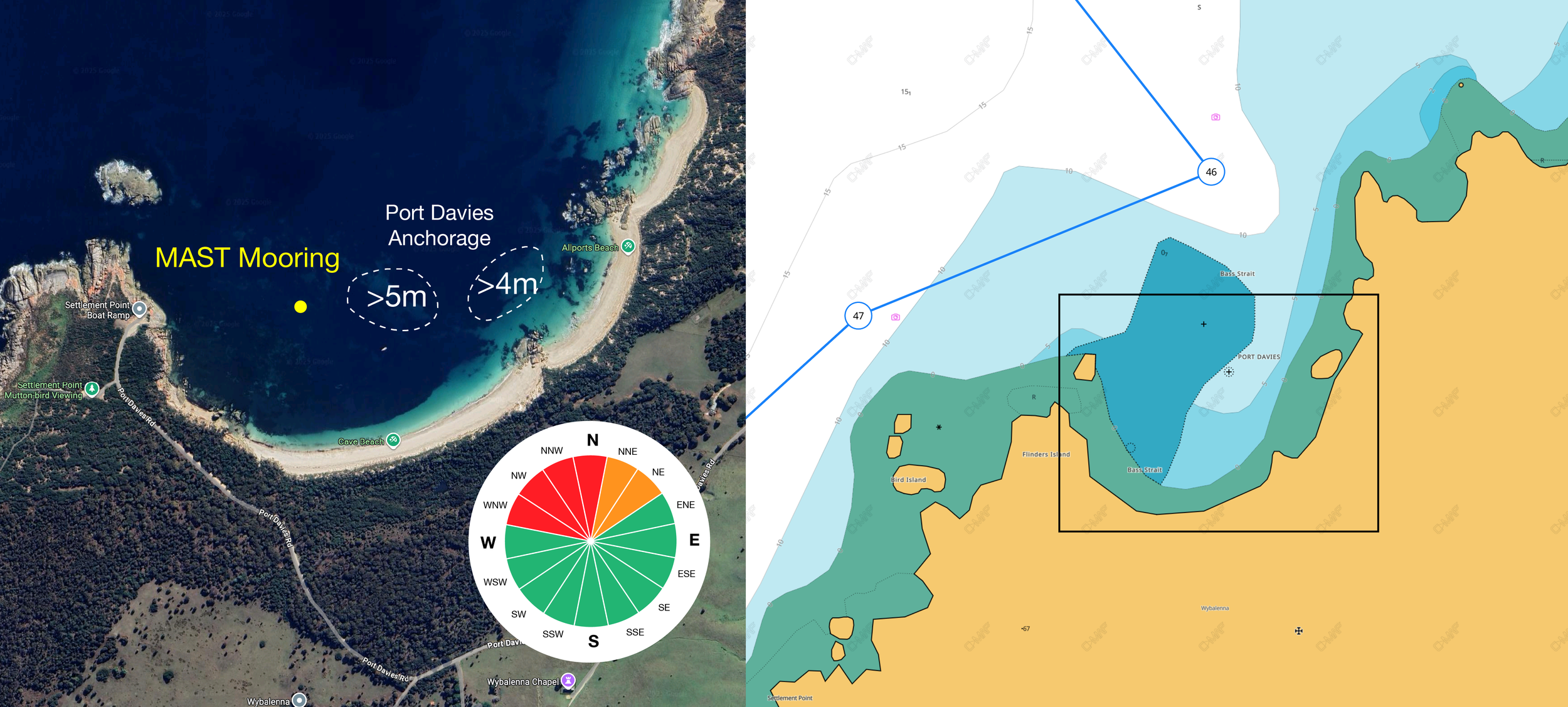
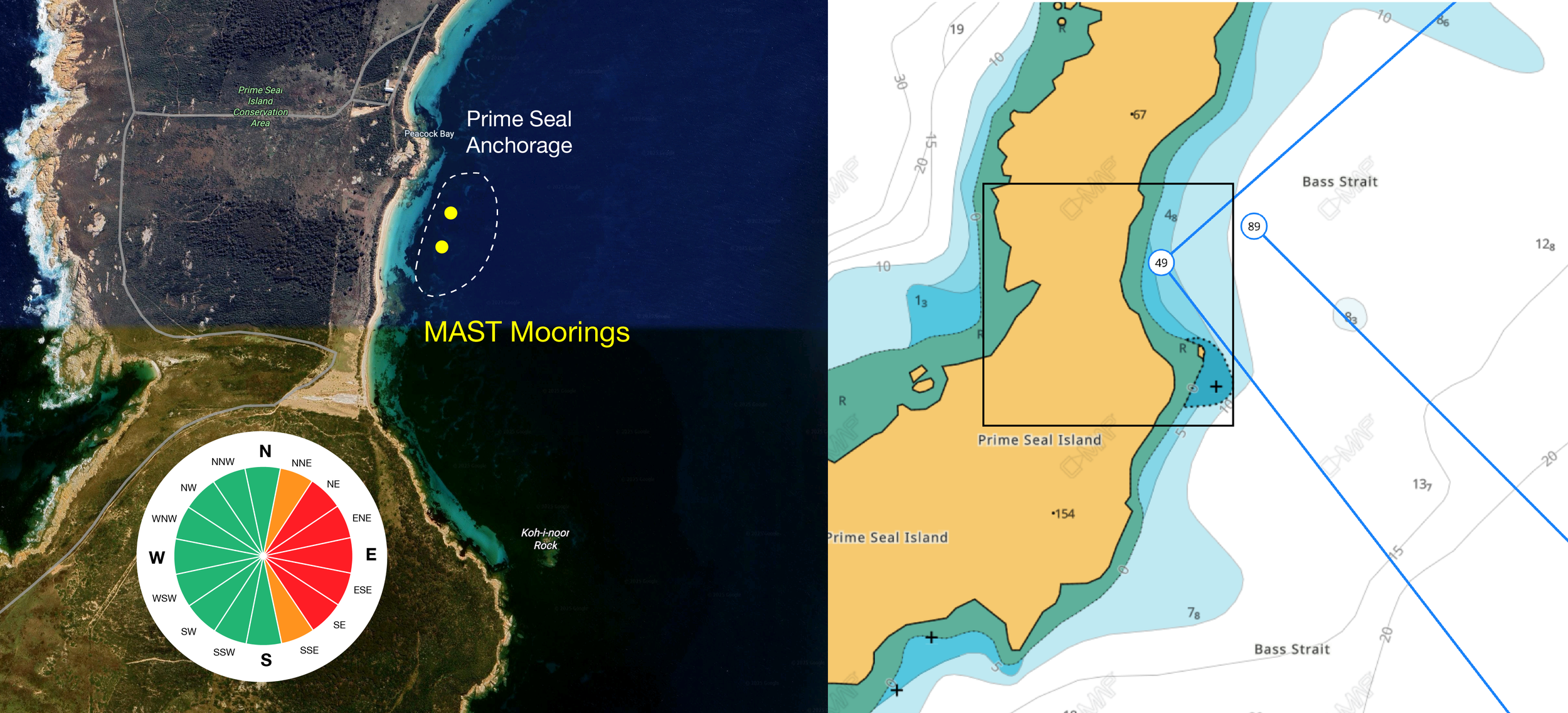
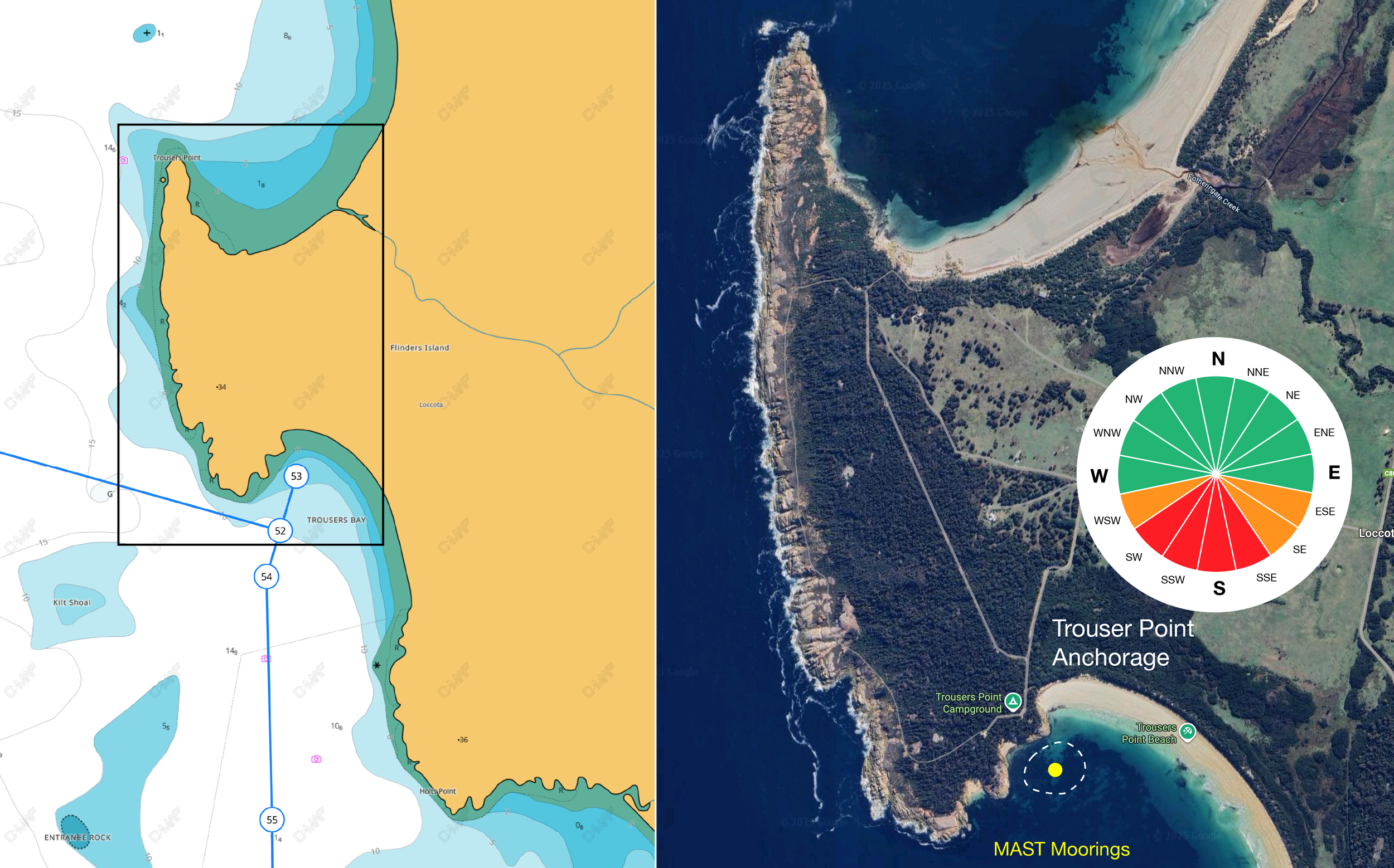
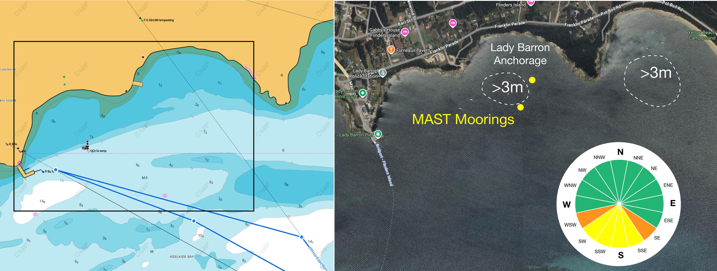
Now we can also use the roses to average trend of the wind direction over the course. This will help us with research on what shelter exists in available anchorages.

Direction Reference Guide. The Main wind directions are coloured, the gray areas are directions where the wind, in January, for whatever tropospheric reasons does not issue from.

This is the rose we’ll use to display the range of safe cardinal aspects in any given anchorage along the way. This one is special as it has four colours and is the ‘Global’ reference for all the roses that follow.

Gray Slices: In all the data, evidence shows wind does not issue from this direction in January.

Green Slices: The Green areas are where wind can issue from, but thankfully, never too strong, usually just nice. The Red and Orange van also have moderate winds but…

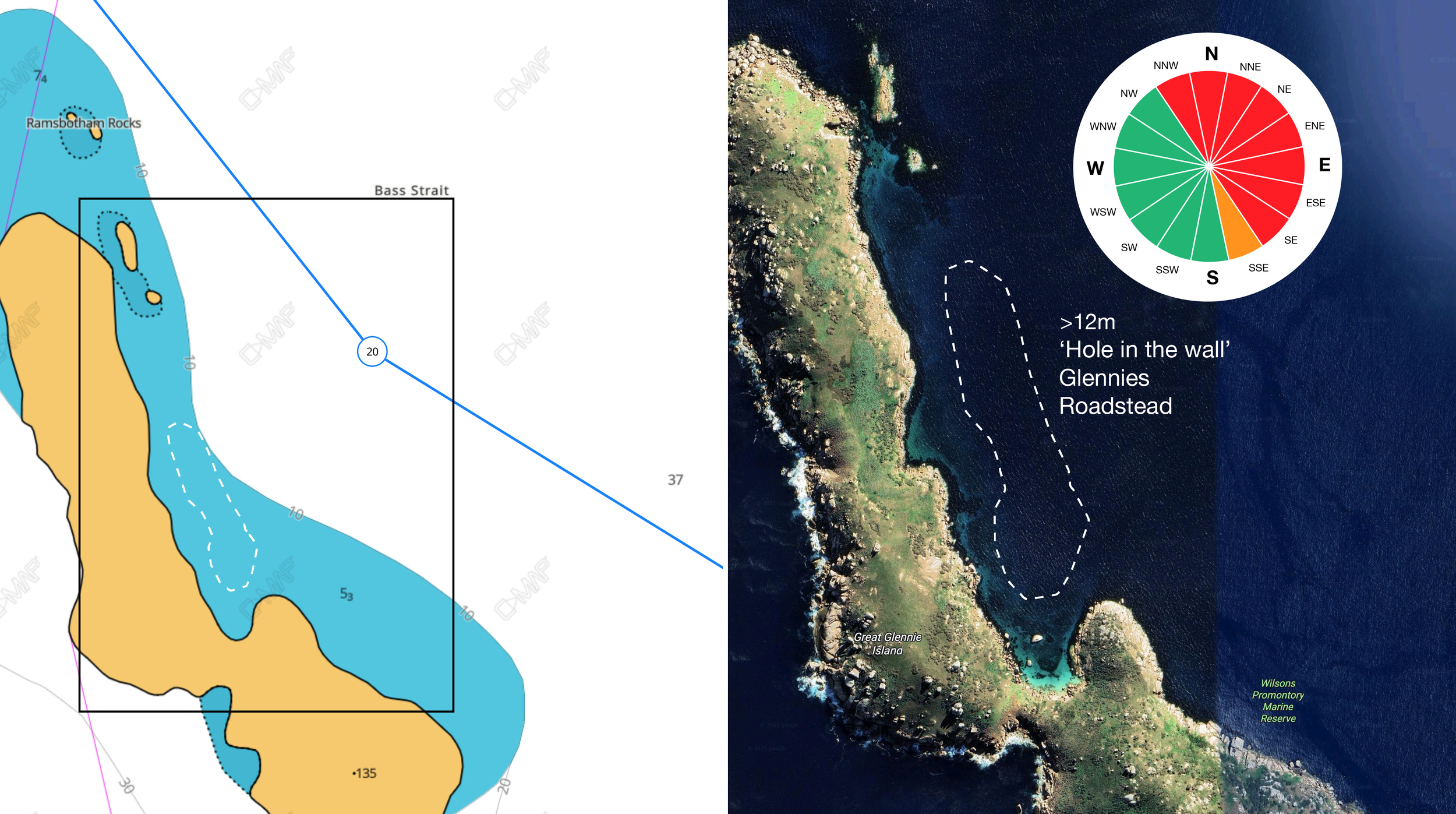
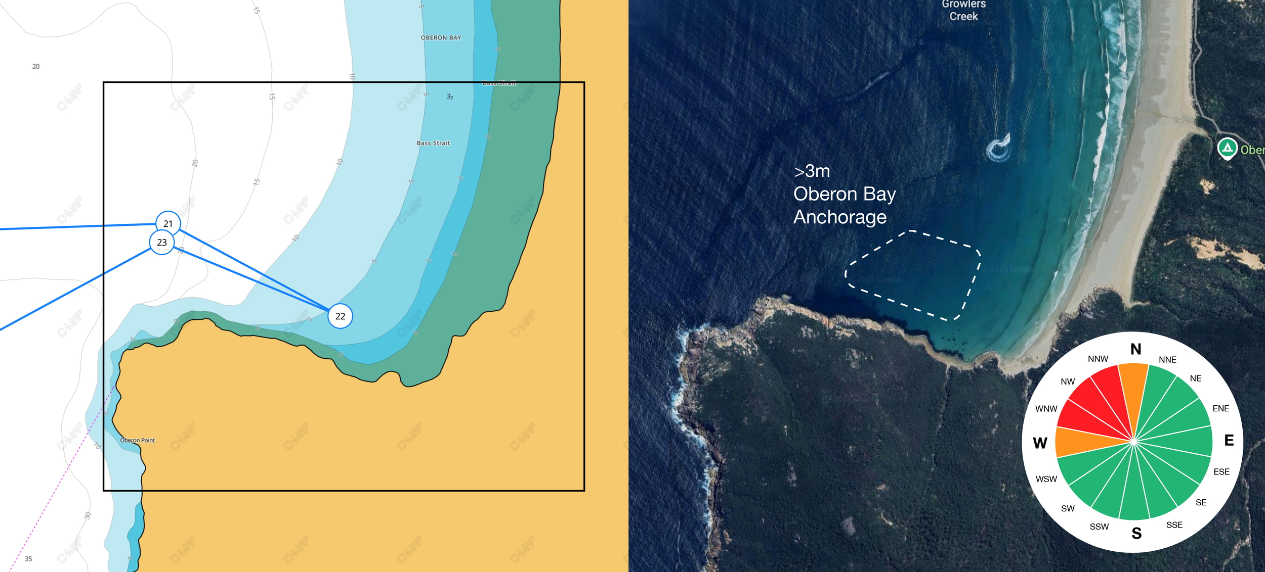
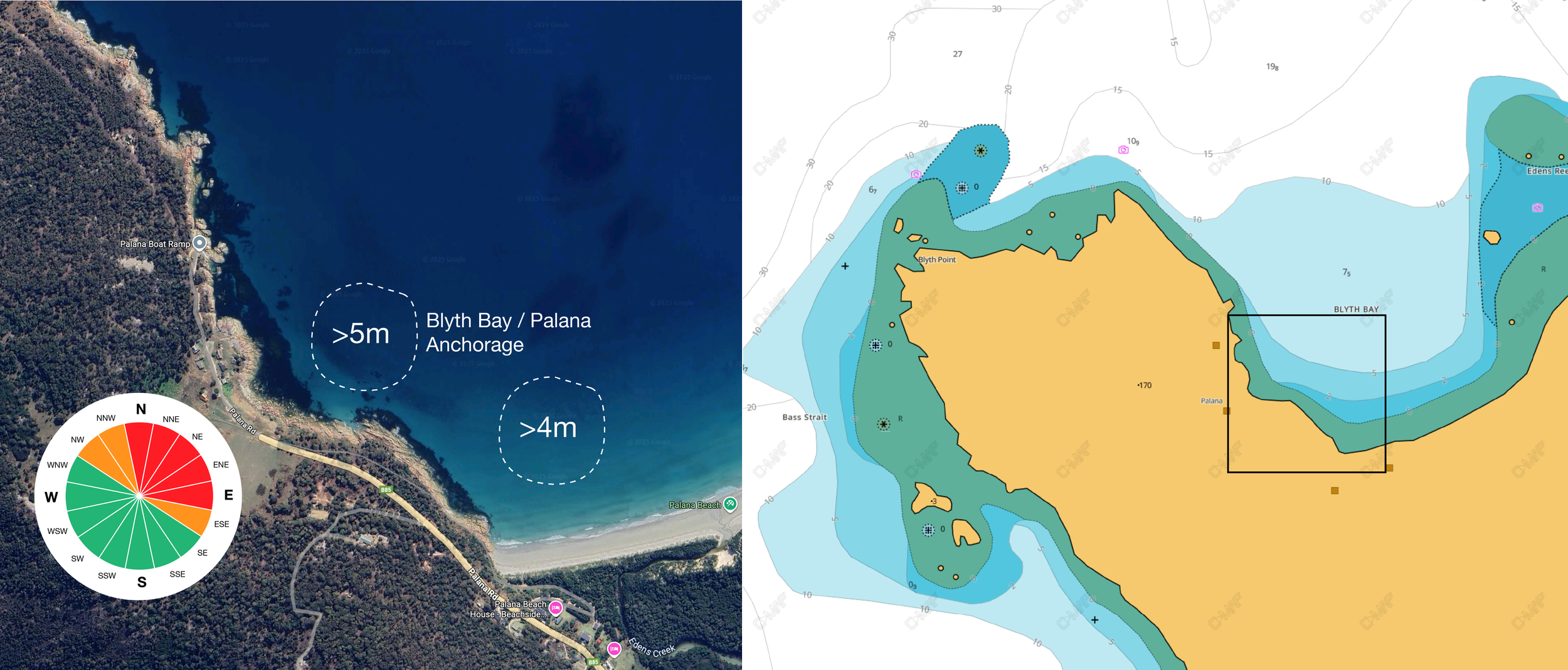
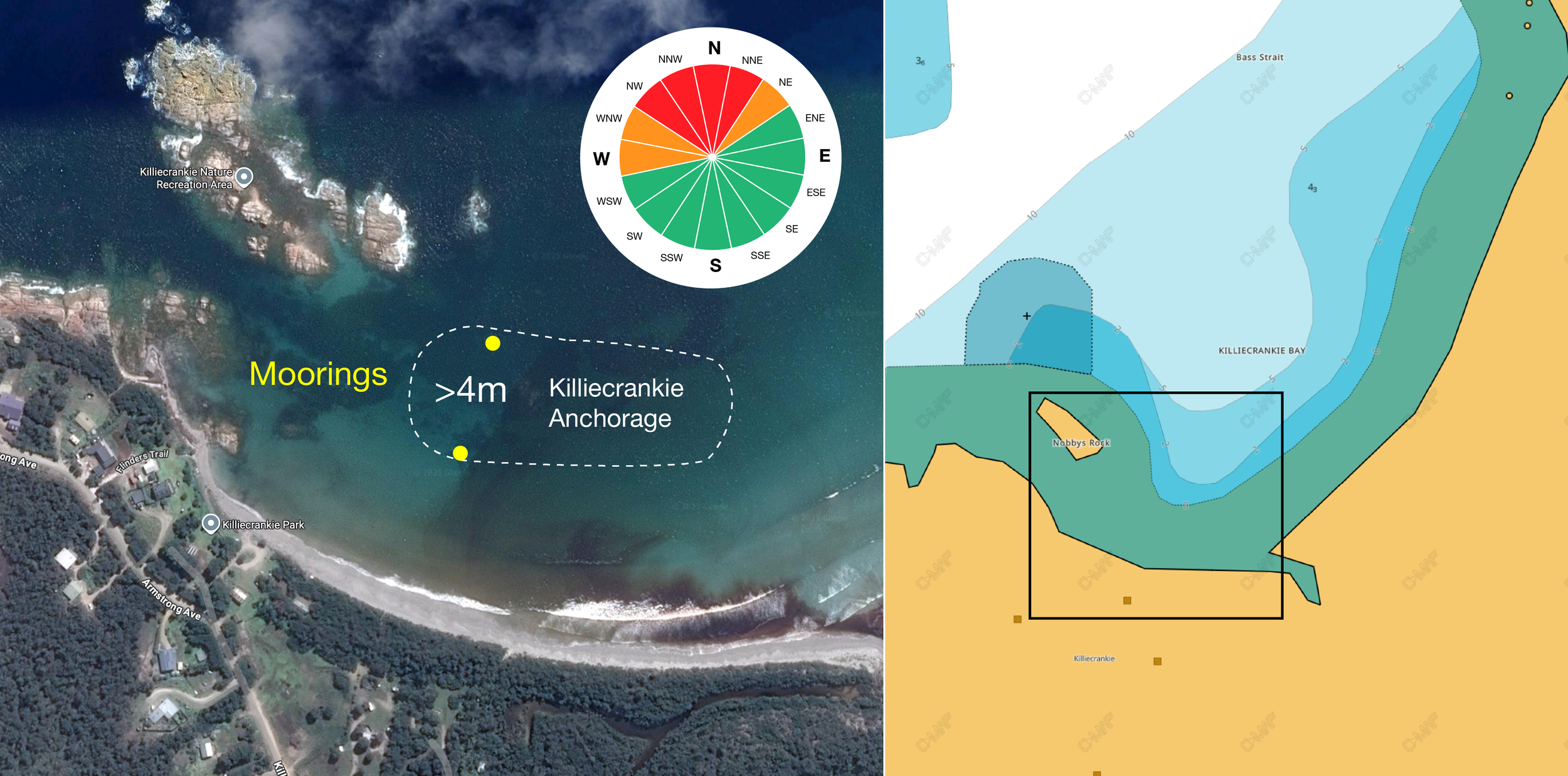
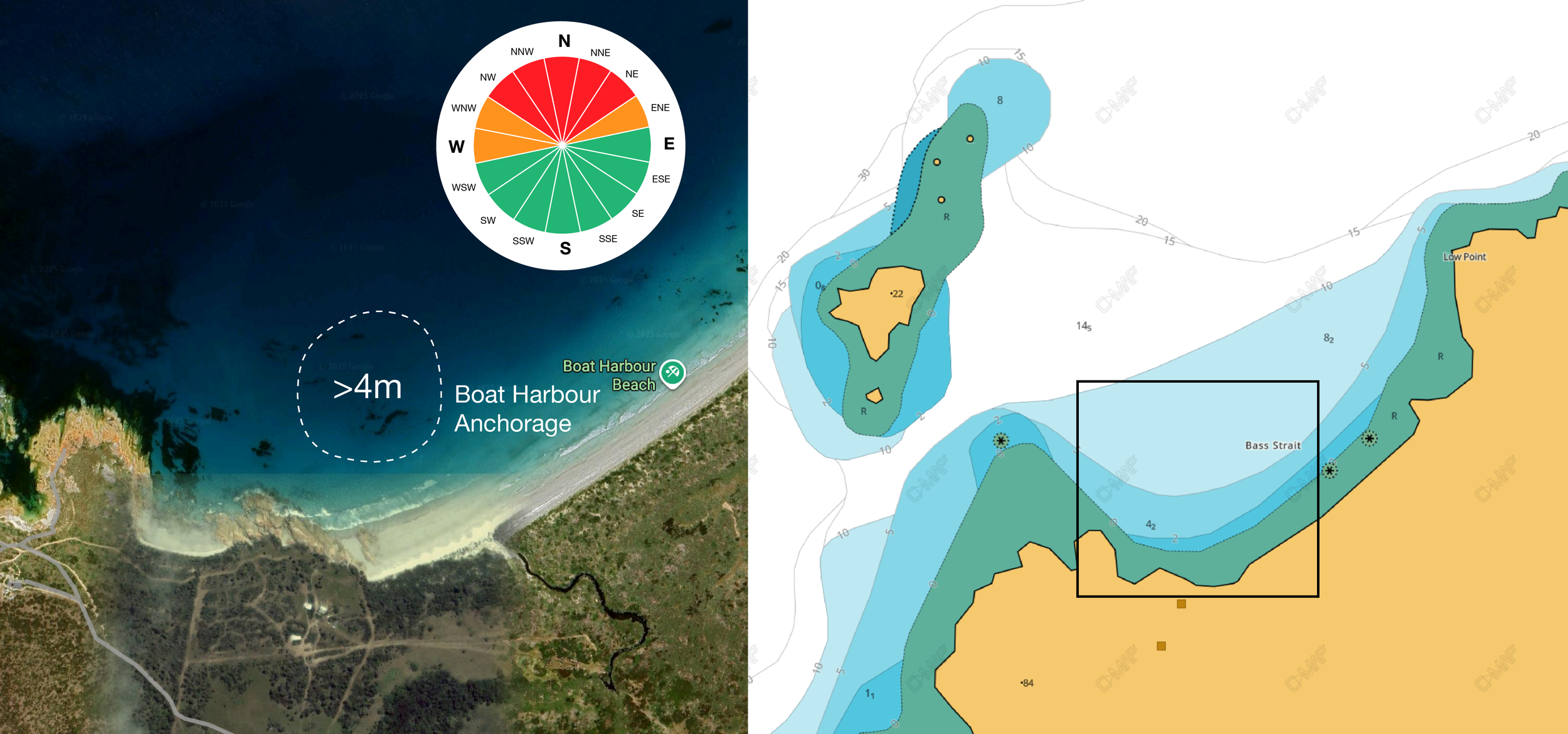
Red and Orange Slices: Show the directions from which storms issue, this is relevant in that we’ll need to be familiar with anchorages that provide shelter from these two quite specific directions, all along the way. W/WSW and E/ENE are the trouble zones.


Swell Trend

Let’s look at the sea state trends also. The proximity of the strait to the southern ocean means it is subject to swell that is issued by storm energy that can happen thousands of kilometres away. Thankfully this energy direction, its ‘set’ is consistently a WSW direction. The important part to note for this passage is that you can see from the sequence below, King Island works as a breakwater to the strait with the exception of the stretch of coast between Cape Otway and Cape Patterson. These are the ‘Surf Coasts’. This energy, in the form of significant ‘ground swell’, can get up to >6m as shown in the pink and crimson areas below. This energy is what makes even ‘sheltered’ anchorages sometimes uncomfortably rolly. A worthy consideration when planning the journey on this stretch. Waters south and east of Cape Liptrap are generally more comfortable as it is only the surface wind wave energy in the system.

Summary of Section 1 of the plan: We have a rough forecast of how far we can travel safely given the time allocated for the trip. We know we have over two days lazing, swimming, fishing and diving, for every day we spend underway. Thats a nice ratio. We also know where we need to find shelter, and that in a 30 day window we are likely to see one ‘blow’ from either the East or the West.

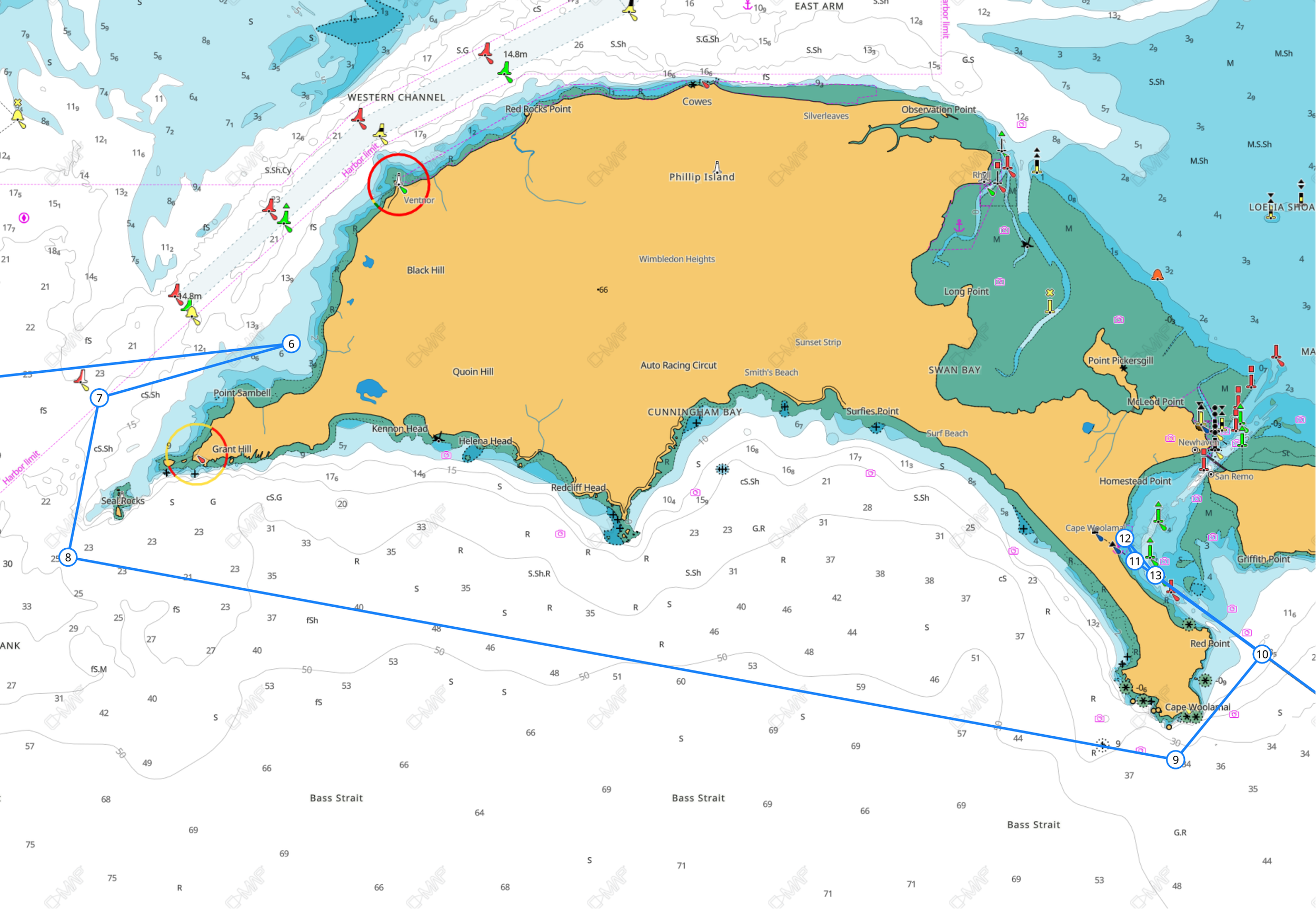
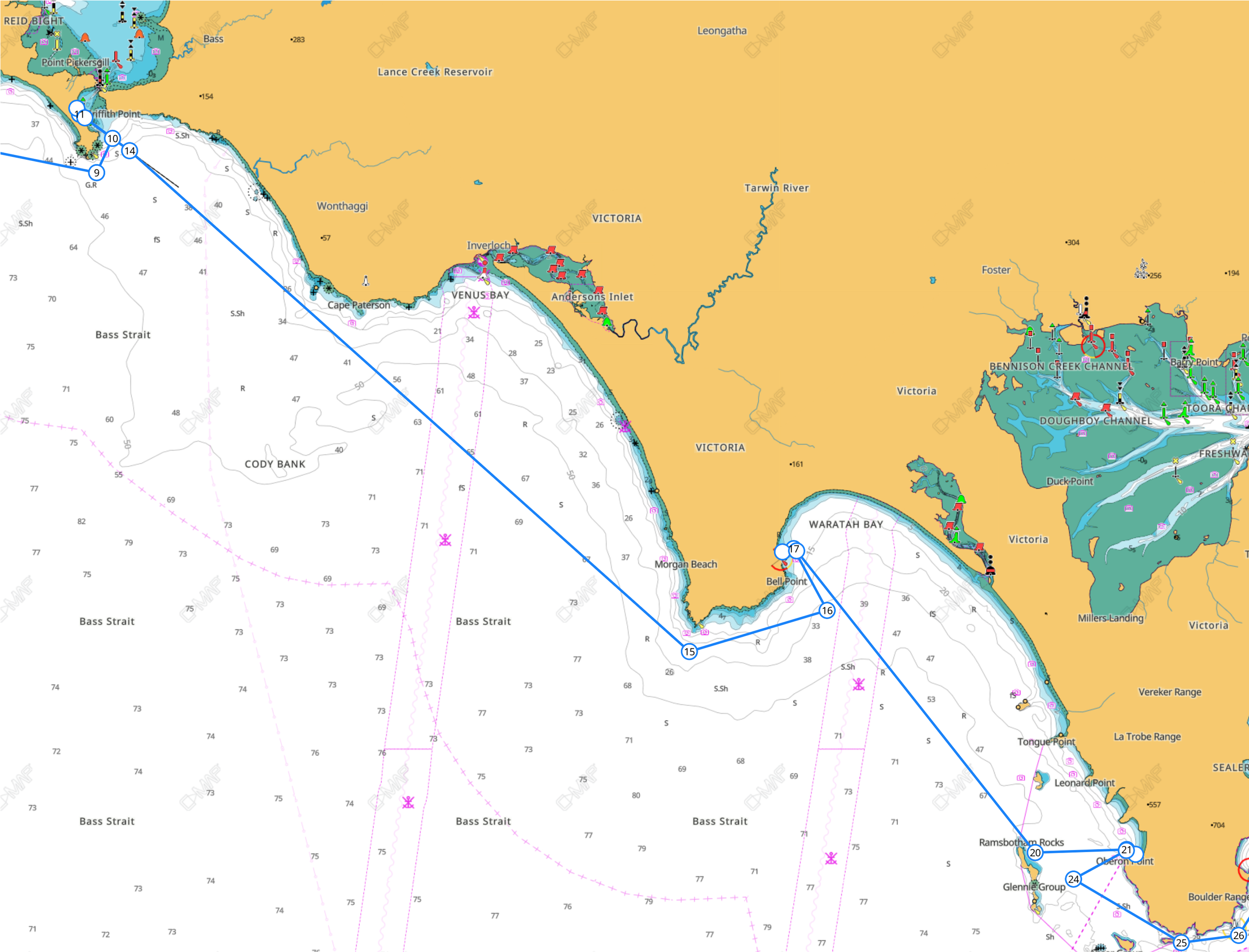
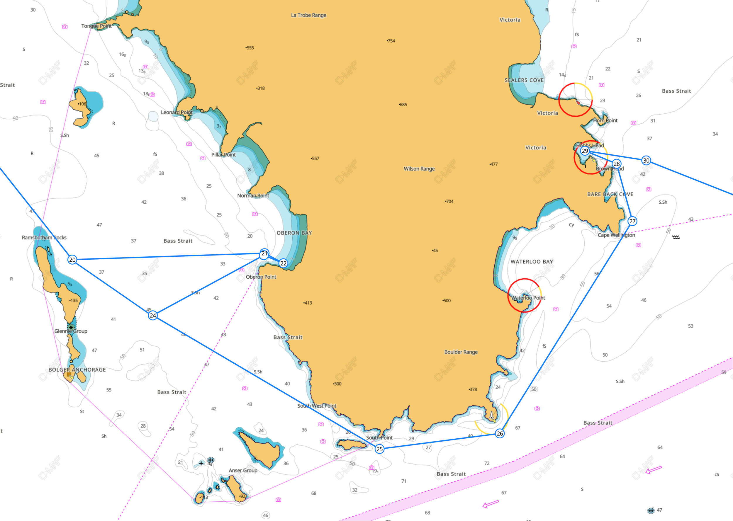
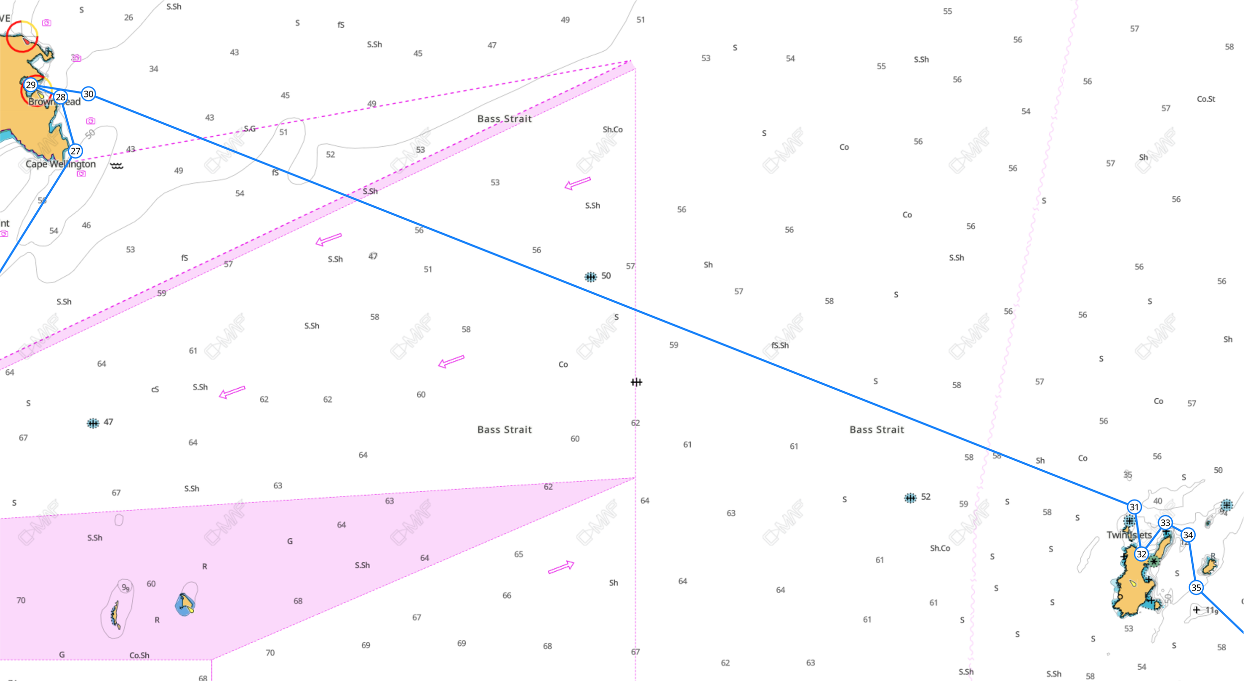
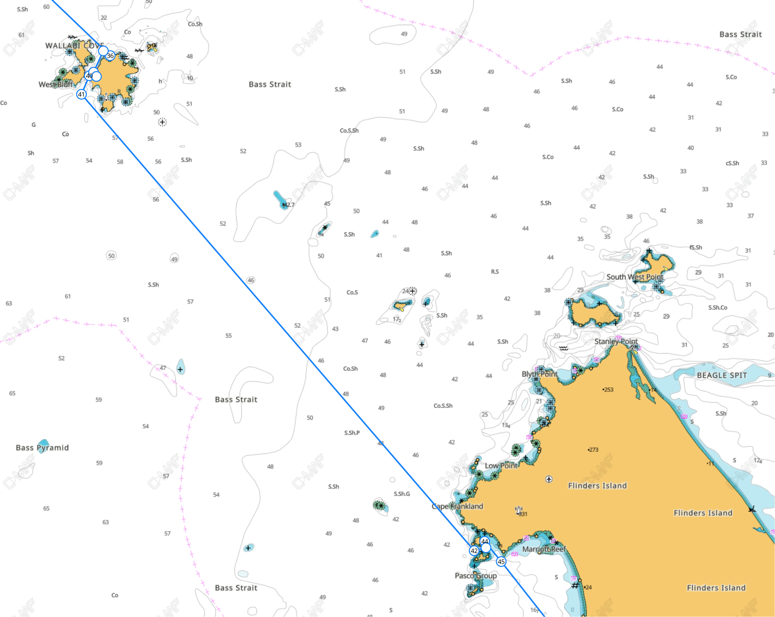
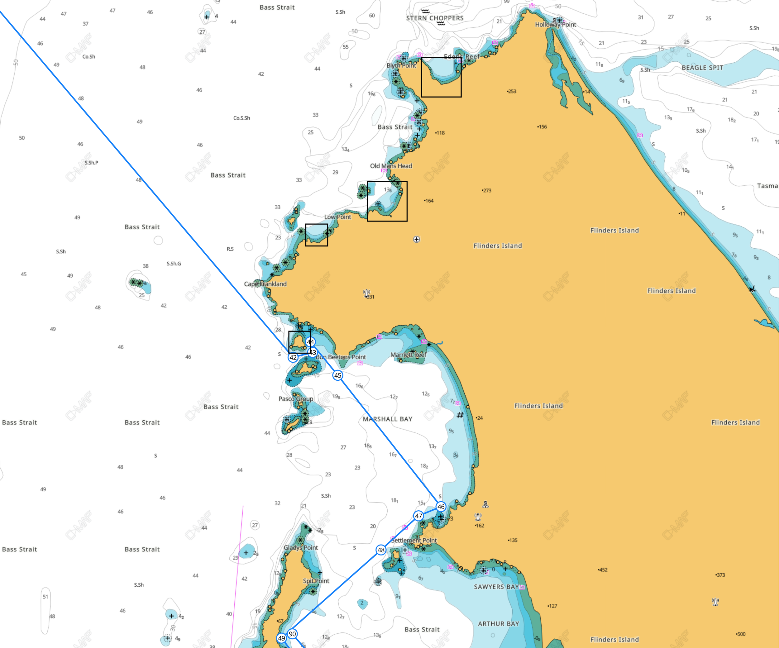
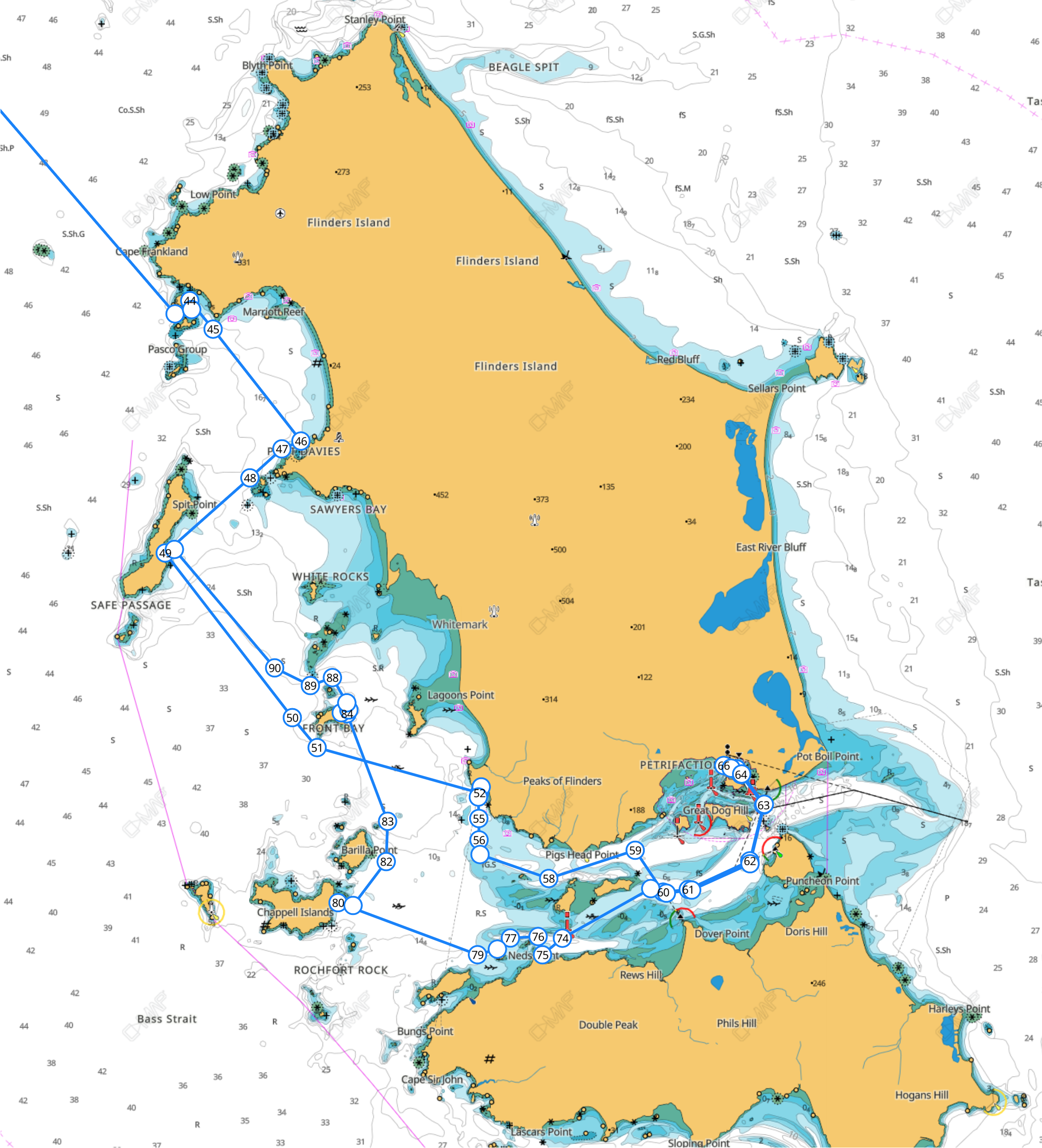
Before we go further jump in and take a look at the proposed course here:

Link to Map

TSA Logbook Download

Download TSA Log Book

Here is the TSA (Total Situational Awareness) Log Book / Trip Planner which is handy for recording and working out the Macro picture.


Overall outward passage planner overview.


 Section Two: Sailing Legs and Anchorages.

Port Phillip Heads.

Ranked as the Somethingest most dangerous water way in the world we need to be cautious and observant of quite a few factors just to break free of the ‘Bay’ into the big deep blue. On the right are slack tide times at the heads. A fleeting half hour window, where if everything else aligns we find flat water in the otherwise turbulent meeting of two large masses of water.

To be sure that we will actually find flat water its worth checking storm surge activity as far back as 62 hour prior, and if there has been any, expect an outgoing tide to be running. It is worth calculating which are the two outgoing ‘sets’ of the four. Note they advance by roughly a half hour everyday.

Conveniently enough for us on this plan, the outgoing tide is the 7:34 am slot on the 25th and the corresponding mid morning and late evening slots through until the start of Jan.

Tide Times: The Rip 2025
Tide Times: The Rip 2026
Learn more about the RIP ENTRANCE HERE

Date / Slack Time / Max Time & Rate


Out of the heads, following the ‘Four Fingers West’ Leads we will swing course to East, and head to Cape Shanck. Then change course to the western entrance of Westernport Bay. Here we choose wether we need east or west shelter available at either Cat Bay (6hrs sail time) or slightly earlier at Flinders (5.5hrs). Crew care kicks in here, people will be feeling grotty. Seek the flatest water for motion acclimatisation.


Phillip Island

The next leg we’ll head back out to a distance to seaward of the ‘knobbies’, the rock escarpments extending south west from Phillip island. Then change course to Cape Woolamai. On making Woolamai we change course to head into the eastern entrance of Westernport Bay. The leading lines start a long way out, we cut the corner as its all deep water. This passage gets tight as the channel is perhaps only 30m wide for a short distance. Check your charts.

Cleeland Bight

This is a broad sweep of beach with good holding and wrap around protection. The only bummer is that it can get tide ripples which make for 3 hours of rolling during the middle of the outgoing tides.

Do the Cape Woolamai Pinnacles Walk. It’s close, starts right from the Bight side, and gives you the best scenery on the island — cliffs, granite walls, ocean views, and an easy loop back along the beach. If you only do one walk, that’s the one.


The Big Stretch: Phillip island to Waratah or the ‘Prom’

This is a stretch. 10hrs Bird Rock, or 11hrs to the outlier islands of The Glennies. Once you make Cape Liptrap you can make that call as to the anchorage for the night. I usually get going early, a couple of hours before dawn, so that by the time sleepy heads get out of bed, the view includes the days cruising objective.

Walkerville / Bird Rock

A pretty spot with good holding and a little holiday village.

The Walkerville Lime Kilns
Built into the cliffs between the 1870s–1920s, these kilns once produced high-quality lime that was shipped by boat to Melbourne. You can still walk right up to the preserved kiln faces at low tide.

Bird Rock
A distinctive offshore rock stack at Walkerville South, popular for photography and fishing. At very low tide you can reach the rock platform around its base.

Historic Tramways & Jetty Remains
The lime operation once had wooden tramways running along the shore and a 300-foot jetty. Rotten piles are still visible in the water today.

Natural Caves & Workings in the Cliffs
The lime industry left cut-outs, tunnels and caves in the limestone cliffs — some are still accessible on the coastal walk between Walkerville North and South.

Walkerville Coastal Walk
A short, scenic track linking North and South Walkerville, passing the kilns, quarry sites, Bird Rock viewpoints, and old workers’ camp remnants right along the edge of Waratah Bay. Includes awesome fish and chips at the caravan park.


The Hole in the Wall:
The Glennies Anchorage.

The Alternative is quite the opposite, alarmingly remote and pristine: no fish and chips here.
The Glennie Group is a small cluster of rugged granite islands off the west coast of Wilsons Promontory in Victoria, including Great Glennie Island, Citadel Island, Dannevig Island, and McHugh Island. These islands are characterized by boulder-strewn shorelines, coastal cliffs, and pockets of tussock grassland and heath, with little to no freshwater. Surrounding waters feature granite reefs, boulders, and rich marine habitats, supporting a diverse array of fish and invertebrates. Judging by the macerated dolphin we found here once, perhaps a bit sharky too.

Ecologically, the Glennie Group is highly significant. The islands are part of the Wilsons Promontory Islands Important Bird Area, providing vital breeding grounds for seabirds such as shearwaters and penguins, while also offering habitat for seals and other marine wildlife. Human access is largely restricted to protect these fragile ecosystems, as the islands are remote, exposed to rough weather, and largely undeveloped. Despite this, their combination of rugged granite terrain, undisturbed vegetation, and rich marine life makes the Glennie Group an important conservation and scientific area, preserving a rare example of Victoria’s offshore wilderness. The birdlife will keep you up at night… what a unique joy.

If its really hectic there is space for a boat to tie ‘fore-n-aft’ between two boulders right up in the bacl of the cove. The ‘Hole’ in the cliff on shore has pirate treasure, and perhaps a curse.

Oberon Bay

On the west coast of Wilsons Prom are a series of white sand bays (Leonard, Norman/Tidal River, Oberon). The pick of the bunch being Oberon on its southern most shore, providing NE to WSW shelter. The nuance is that the outer islands of the Glennies act as a break water and the SW ground swell is diminished by comparison to what might normally be expected. The more southerly of these beaches enjoys the best ‘breakwater effect’. That said it can still be rolly and is only really good in winds S through to North and East. There is also a wind funnel effect created in easterlies that, combined with Katabatic effect can see easterly gusts ~40% stronger than forecast.

NOTE: West Prom Shuffle.

The distance between the Glennies ‘Hole in the Wall’ and Oberon Bay anchorages is about 4Nml. For cruisers who are enjoying this side of the prom this provides all weather protection with a short hr trip required between the two.

Oberon Bay anchorage bottom left with the ‘Hole in the wall’ top left. Pic courtesy of Parks Vic.


Rounding the Southernmost point of the Australian mainland:

South Point, Wilsons Prom.

This guide is not about navigation, and the information is simply based on personal experience and other may find conditions contrary to what is described here. Rounding the South Point from West to East is an exciting leg. The current set is worthy of consideration as it can create very short steep seas as would be expected, in opposition (although also through constriction / reflected swell) to wind direction. With very diligent navigation the passages between either Anser and or Wattle island both have deep water 30m+ which provides protection for the approach to South Point. The leg between South Point and South East Point (the Lighthouse) its prudent to leave space to avoid the reflected swell <1Nm distance, heading due east from the South Point until well clear of South East Point.

Check the Tidal Rate Forecast at South Point here.

The famous Wilsons Promontory Lightstation (Credit: Heather Rose). Here you can see the passages between the Anser and Wattle Islands.


Wilsons Prom East Coast:
A Cruising Paradise

Click to enlarge.

Waterloo Bay

The Waterloo Point anchorage is good for a quick freshen up (or flatten out) after the trip around the South Point. With only space for a few boats, and weedy bottom its a roadstead, more than an anchorage. Probably not a place to see out a significant blow from any direction. The North Shore of Waterloo Bay is a smorgasbord of shelter from N through NE, watching for shallow water extending from North Waterloo Bay Beach.


Refuge Cove and surrounds.

Refuge cove, predictably as the name suggests, offers great refuge. A proper hide-out for serious westerlies. The South Anchorage being the most popular and busiest. With that comes the challenges of dealing with other boats. Here we have suffered a midnight attacks from a catamaran ‘Its a Privilege’ who was scoping a spot to drop the pick with cabin white lit and couldn’t see us (or simply wasn’t trying) or our mast head light. Resulting in a very near miss with them steaming at +3kn and us stationary at anchor. Similarly boats dragging onto other boats is a classic, so a word to all boating users, expect people, be a diligent mariner and keep a watch on approach, leave plenty of rode, and take evasive action if you are dragging anchor.

Evasive action might also include not staying here if its really crowded. The other alternatives are to anchor in the deep closer to the entrance in 15m, or the Nook, is a good spot to deploy shore lines and snug aft too of an anchor in 5m of water. The fisho’s will try and sneak in behind which makes means adding fender to mark your shorelines is prudent. Climbing equipment and chafe protectors are your best bet for making a good hide-out.

Birthday Bay is found to the south of the main Refuge Bay entrance and whilst open to NE it has better holding in 4m of water.

Local Valley Effects and Rotors. Within Refuge Cove in the event of say a SW Gale (not uncommon any time of the year) the boats observed at anchor can yaw along a 100˚ arc. This is due to the combined three effects. The moderate gusts are Katabatic winds that blast down slope from the SW. The Valley Effect follows with wind issuing from the creek at the SE corner of the south beach, and for some really strong gusts can create a rotor at ridge top which exctends to the waterline and is 180˚ to the prevailing wind direction. This probably explains some of the chaos experienced when the south anchorage is crowded.

The Headland north of the entrance to Refuge is Horn Point. Here are a couple of neat options for anchorages / roadsteads to visit for day trips. Good diving and pretty views. The space is limited to one or two boats at a time.

Sealers Cove

Sealers Cove is a large Bay north of Refuge Cove area. It offers good shelter from the SE through NW.


Crossing the Strait Part One: Wilsons Promontory -
Hogan Island - Kent Group (Deal and Erith Is)

Refuge to Hogan Island.

The 26 Nm stretch from Refuge Cove to Hogan Island has three important considerations. Crossing the shipping channels as they converge to round the prom. Shipping will regularly transit at <20kn meaning that considerable caution needs to be made. Obviously AIS helps heaps here. Tidal set on approach to Hogan island can travel at 3kn either NE and SW directions across the route. Making calculations to compensate for this saves time and avoids hazards. Lastly, the anchorage / roadstead is only sheltered for winds West through to South East and the open to the North East. This constraint dictates the available duration stay at the island. The anchorage has good holding at a depth of 12m on sand.


Hogan Island, part of the Hogan Group in Bass Strait, was once a land bridge to mainland Australia, isolated by rising seas post-ice age. Named by John Black in 1802 after his ship's owner, it became a sealer/kangaroo hunting spot, then leased for grazing (sheep/cattle) until damage halted activity. Today, it's a conservation area, famous for its unique marine life and its smallest neighbour, Boundary Islet, which famously straddles the Tasmania-Victoria state border due to a mapping error. 

Early History & Naming

  • Land Bridge: The Hogan Group was the first part of the Bass Strait land bridge to be separated as sea levels rose after the last Ice Age.

  • Naming: Captain John Black of the Harbinger named the group in 1802, after Michael Hogan, owner of the ship. 

Sealing & Settlement

  • Sealers' Haven: Soon after discovery, sealers frequented the islands, hunting seals, then kangaroos, and using them for grazing.

  • Grazing: The first official lease for Hogan Island was in 1900, used for cattle and sheep by B.R. Stackhouse, but grazing stopped due to environmental damage. 

Modern Era & Conservation

  • Conservation: The islands are now primarily conservation areas, with seals as the main inhabitants.

  • Boundary Islet: A tiny islet in the group, North East Islet (now Boundary Islet), has a unique east-west border, making it Australia's shortest state land border, a result of a surveying error by John Black. 


Hogan Island to Kent Group

A short distance south of Hogan Island and Erith island should be visible given clear conditions due to its significant height. A distance of 20Nm to the south east.

On approach to the islands you will be facing Wallabi Cove. The closest shelter. Reportedly rolly, this anchorage has good shel†er from the all winds except North Westerlies.

To the east of Wallabi is the entrance to Murray Passage, the water dividing Deal and Erith Islands. and to the east of that is Garden Cove.


Garden Cove.

Anchor in 5m of water and expect strong SW winds to alter course to S due to rotors and valley effect. There is space enough for several boats.

Historically significant as a site for a sealer's camp in early British occupation, a source for freshwater & vegetables for lighthouse keepers, and where Aboriginal women were held, a site documented by George Augustus Robinson in 1831. Its name reflects the island's use for sustenance gardens, connecting to broader Tasmanian history of early settlements and resource use. 

Early Aboriginal Connection & Sealing Era:

  • Before European arrival, this area was part of the traditional lands of the Palawa people.

  • In the early 1800s, Garden Cove became a base for sealers, men involved in the sealing industry, notorious for kidnapping Aboriginal women, as noted by George Augustus Robinson's historical accounts in 1831. 

Lighthouse Keeping & Sustenance:

  • Later, when Deal Island became home to lighthouse keepers, the cove's freshwater stream and fertile ground made it ideal for establishing gardens to provide fresh produce, preventing scurvy, a common issue for isolated crews. 

Significance of "Garden Island" in Tasmania:

  • While "Garden Cove" is specific to Deal Island, the broader concept of "Garden Island" (like the famous one in Sydney Harbour) highlights the early colonial priority for ship's gardens for fresh food. Tasmania, as part of Van Diemen's Land, shared this focus, with settlements like Port Arthur also developing extensive gardens for self-sufficiency. 

In essence, Garden Cove represents a convergence of Aboriginal history, early sealing exploitation, and the practical needs of colonial maritime life in Tasmania's Bass Strait islands.. 


Murray Passage Anchorages

Click to enlarge.

Erith Island: West Cove Anchorages.

This is the scene of one of those epic battles by a family, on their boat fighting a dragging anchor in a gale. Eventually they ditched into the beach just south of the hut at the north end of the beach. It turns out that the whole area at the north of the cove consists of shallow sand over rock with weed. A nasty mix, and poor holding. If you have heard horror stories of anchoring at Erith it was likely the result of this. South and west of this are is in fact reasonable to good holding (the sand here tends to be the big granular granite sand like the north end of Refige Cove and is not super sticky. Yet with no weed and room for plenty of rode this is a great hide-out in a SW gale. If there is an easterly ground swell you will find it here. In strong winds the rotor effect off the ridgeline can become so strong you will pivot 180˚ and face East. Be wary of snatching the anchor if this happens.

East Cove, Deal Island

The East cove of Murray Passage on Deal Island is the most popular in the Kent group. Perhaps due to the proximity of walks in the area, the historic ranger / lighthouse station.

The main area is immediately off the beach. With some vessels choosing to stay on the sandy patch below the steep hillside to shelter from strong / gale easterlies to avoid the valley bullets.

Deal Island's history centers on its iconic, highest-in-Australia lighthouse (built 1848), crucial for Bass Strait navigation, leading to a significant maritime past with shipwrecks and lightkeeper tales, eventually becoming part of Kent Group National Park, with current management by Tasmania Parks and Wildlife relying on volunteer caretakers for its historic buildings like the old Superintendent's Cottage, now a museum. 

Early History & Lighthouse Construction 

  • Naming: Named after Captain William Kent, from the First Fleet.

  • Construction: The granite lighthouse, Australia's highest (305m above sea level), was a joint project by NSW, Victoria, and Van Diemen's Land, opening in 1848 to guide ships through treacherous Bass Strait.

  • Challenges: Its high elevation meant the light was often obscured by cloud, limiting its effectiveness. 

  • Maritime Significance & Tragedy 

    • Shipwrecks: The waters around Deal Island (part of the Kent Group) are notorious for shipwrecks, with strong currents claiming many vessels like the Bulli and Karitane.

    • Lives Lost: The island holds graves of various people, including seals, seamen, and even a WWII RAAF crew from a 1943 crash. 

Management & Conservation

  • Ownership: Ownership transferred to the Commonwealth, then returned to Tasmania, leading to the 2001 proclamation of Kent Group National Park.

  • Decommissioning: The lighthouse was deactivated in 1992 when automated lights were installed nearby, but volunteer caretakers now maintain the historic site.

  • Heritage: The site is listed on the Tasmanian Heritage Register, preserving its significant lightstation buildings, including the Superintendent's Cottage. 

Modern Day

  • Access: Extremely limited, usually by private boat or charter, as the airstrip is closed.

  • Volunteers: A small, dedicated group of volunteer caretakers live on the island to protect the heritage structures. 


Winter Cove

Another hot pick for weathering a westerly gale, Winter Cove on the west side of Deal Is has good holding in 5m of water, 200m off the beach. The only drawback being the topography inland of the cove creates a funnel valley effect and intensifies the wind strength. To combat this shore lines could be deployed although they need to exceed 100m to be of any use. Not a place to be if the winds are easterly at all.

Squally Cove (little Squally Anchorage) is actually really sheltered although it goes have the same challenges mentioned associated with Refuge Cove in strong westerlies in that between the Katabatics effect, Valley Effect and Rotor effects the wind, as the name suggests can issue from any direction. That said due to the scale and steepness of the protective ridge line to the east, wind velocity is diminished to <50% of the prevailing force. A great place for a day trip to visit the wreck of the SS Karitane

The Squally Cove wreck on Deal Island, Tasmania, refers to the steamship Karitane, which ran aground on Christmas Eve 1921 while en route from Devonport to Port Kembla. Remnants of the Karitane, sometimes called Wreck Cove, are still visible on the pebbled shores of Squally Cove on the island's eastern side, a popular site for visitors exploring the Kent Group. 

Key Details:

  • Vessel: SS Karitane (Union Steamship Company).

  • Date: Christmas Eve, 1921 (December 24, 1921).

  • Location: Squally Cove (also known as Wreck Cove) on Deal Island, Kent Group, Bass Strait.

  • Outcome: Captain and crew made it ashore safely, though the ship was lost.

  • Significance: The wreck is a notable historical feature of Deal Island, with parts of the vessel still accessible. 


Kent Group to Flinders Island.

The transit from the Kent Group to the northern shore of Flinders island is a 30 Nm trip on a bearing of 140˚. On transit you past to the west of Wright and Beagle rocks, then Craggy Is. A 2kn SW tide set can occur on flood tides, requiring a bit of planning. Options on making landfall are varied, see below. The rest of this site is still draft and under construction. Handy reference included below.

Palana / Blyth Bay.

Best spot around for shelter from westerly gales,

Killiecrankie Bay

Reasonable shelter, there are private moorings in the bay that with permission from the local residents can make a re-supply an option, with a car hire to Whitemark.

Boat Harbour

Another Spot for a visit. Pretty beach, pretty exposed to the SW with only low hills ashore.

Roydon Island and West End Anchorage

This is mini archipelago offers good protection in combination from SW and NE winds. Picking sand between the sea grass is the challenge. Good holding on both sides of the bay.

Roydon Island is a small, picturesque island (around 37-53 hectares) in Tasmania's Furneaux Group, located off Flinders Island in the Bass Strait, known as a stop for kayakers for its white sands, rustic hut, and natural beauty, part of the Roydon Island Conservation Area

Key Characteristics

  • Location: Eastern Bass Strait, part of the Furneaux Group, near Flinders Island, Tasmania.

  • Size: About 37-53 hectares (approximately 90-130 acres).

  • Features: White sand beaches, granite formations, a small hill, a rustic hut, and a natural harbour.

  • Conservation: Designated as part of the Roydon Island Conservation Area under Tasmania's Nature Conservation Act.

  • Nickname: Often called "The Kayaker's Island" due to its role as a key stopover for Bass Strait crossings

Activities & Significance

  • Kayaking: A popular spot for kayakers exploring the Furneaux Islands, offering calm waters and scenic stops.

  • Nature: Known for its geological features, including ancient sand dunes and granite outcrops.

  • Environment: A focus for environmental efforts, like weed management by Weedbusters. 

Visiting

  • It's a remote island, typically accessed by boat or kayak, with limited facilities beyond a basic hut, making it a destination for adventurous visitors. 


Port Davies. Wyballena

Port Davies is a neat little north facing nook, similar in characteristics to Killicrankie Bay. Finding sand amongst the sea grass is the key to gaining a good connection with the bottom. A MAST moring is located in the middle of the bay. Some charts feature a large shallow patch in the middle of the bay, while others (Sonar Charts / Navionics) dont. Venture with care. Also, if you visit the shore you will also want to venture with care and respect:

The Wybalenna Chapel on Flinders Island, Australia, is a poignant remnant of the tragic Wybalenna Aboriginal Settlement (1830s-1847), a forced relocation site where many Tasmanian Aborigines (Palawa) died from disease, poor conditions, and homesickness, while being subjected to attempts at Christianisation. Restored and now managed by the Aboriginal community, the chapel and surrounding grounds serve as a sacred site for truth-telling, remembrance, healing, and cultural connection, acknowledging the past suffering while looking towards reconciliation and future community use. 

Historical Significance

  • Forced Settlement: Established by George Augustus Robinson, it was intended to "civilise and Christianise" Palawa people but functioned as an internment camp.

  • High Mortality: Poor conditions led to the deaths of around 130-150 people, including prominent figures like Mannalargenna, from introduced diseases and despair.

  • Abandoned: The settlement closed in 1847, with the remaining 47 survivors moved to Oyster Cove

The Chapel Today

  • Physical Remnant: The chapel is one of the few standing structures from the settlement, often described as having an eerie presence.

  • Sacred Site: It's a place of deep spiritual importance for the Palawa community, symbolising resistance, survival, and loss.

  • Reconciliation: Through efforts by the Flinders Island Aboriginal Association (FIAA), the site is being transformed from a place of mourning to one of empowerment, reconciliation, and truth-telling.

  • Cultural Hub: Plans include using the restored buildings for community workshops and gatherings, allowing the Palawa to share their own stories on their land. 

Visiting Wybalenna

  • Visitors are encouraged to approach the site with respect, acknowledging its tragic history and the ongoing importance of the land to the Aboriginal community. 


Peacock Bay / Prime Seal Island

There are two MAST moorings off the beach near the settlement on Prime Seal Island known of as Peacock Bay. The mooring are necessitated by the thick grass cover.


Trouser Point

Lady Barron